Very inconsistent weekend swell, nothing until late next week

Victoria Forecast by Craig Brokensha (issued Friday 21st June)
Best Days: Exposed beaches later morning Sunday and Monday morning, Friday and Saturday next week
Recap
Easing surf with generally average conditions across all locations yesterday, though there were a few options for the keen. Today is poor with onshore winds and smaller, weaker surf.
Today’s Forecaster Notes are brought to you by Rip Curl
This weekend and next week (Jun 22 - 28)
Tomorrow will remain a lay day as the swell continues to fade and onshore S/SW winds create generally poor conditions.
Our very inconsistent and long-range, long-period SW groundswell for Sunday is on track with it arriving in Western Australia this morning, onwards to us in two days time.
As talked about in Wednesday's notes we may see the wave buoys ping with a long-period signal this evening, but there'll be no size attached to it, with the bulk of the very inconsistent swell filling in Sunday.
There's been no change to the expected size with very infrequent 3ft waves due on the Surf Coast magnets and 4ft waves on the Mornington Peninsula, but every 15-20 minutes we may see bigger 4ft sets on the Surf Coast and 5-6ft'ers on the Mornington Peninsula.
Conditions will improve through the morning on the beaches as a dawn SE-E/SE breeze tends E/NE, and then back onshore into the afternoon. With this the late morning/midday session will be cleanest and the dawny average.
Monday looks great with a N/NE tending N'ly offshore and easing groundswell from a very inconsistent 2ft on the Surf Coast magnets, and 3ft+ on the Mornington Peninsula.
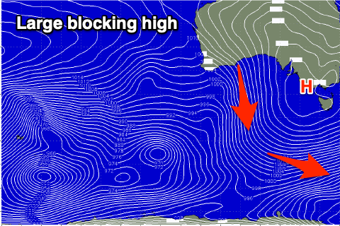 A large blocking high will direct persistent winds from the northern quadrant across us through the week but also deflect swell generating cold fronts pushing up towards WA away from us.
With this the surf will be tiny to flat with nothing of significance due until late in the week with a moderate sized long-period W'ly groundswell fills in.
The source of this swell will be a significant polar frontal progression firing up in the Indian Ocean, in our far swell window.
The size and scope of this storm will result in probably the largest swell of the Indonesian season, with an initial fetch of severe-gale W/SW winds setting in motion a large active sea state for a secondary burst of storm-force W/SW winds to project over.
The long-period and very west swell is expected to arrive Friday, peaking into the afternoon and easing slowly Saturday.
Size wise at this stage it looks like the Surf Coast magnets should come in at an inconsistent 3ft+, with 4-6ft sets on the Mornington Peninsula with a N'ly breeze. More on this Monday though. Have a great weekend!