Small tricky swells continue

Victoria Forecast by Craig Brokensha (issued Friday 7th June)
Best Days: Exposed beaches tomorrow morning and later Sunday, Surf Coast Tuesday for keen surfers, exposed beaches Wednesday morning
Recap
OK waves for the keen yesterday with a mix of new mid-period W/SW swell and S/SW groundswell into the afternoon coming in at 3ft on the Surf Coast and 4-5ft to the east.
The swell was cleaner today and on the ease, with 2-3ft sets on the Surf Coast and 3-5ft waves to the east. We should see winds tend more variable out of the N'th this afternoon, creating a further improvement in conditions across the beaches.
Today’s Forecaster Notes are brought to you by Rip Curl
This weekend and next week (Jun 8 - 14)
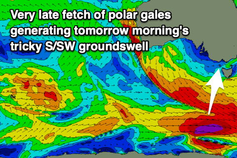 Yesterday afternoon's and this morning's S/SW groundswell was the first and most reliable pulse of tricky swell, with a secondary smaller pulse for tomorrow looking less reliable and very flukey.
This was generated by a very strong burst of severe-gale to storm-force W'ly winds on the polar shelf south-southwest of Tasmania yesterday, very late in our swell window and mostly too east in location to be beneficial.
The swell is due to peak tomorrow morning with sets to 2ft on the Surf Coast and 3ft on the Mornington Peninsula along with fresh N'ly winds, shifting NW into the afternoon. With the swell due to ease through the day and changing winds, hit those exposed beaches before lunch.
Sunday will be clean again but tiny with a fresh N/NW-N tending N/NE breeze. Our new flukey SW groundswell for the afternoon is still just that.
A tight low is due to form south-west of us tomorrow morning, but track quickly east-southeast while generating a very small burst of severe-gale to storm-force W'ly winds.
The swell from this low should fill in Sunday afternoon, though size wise I wouldn’t expect much over 2ft on the Surf Coast magnets and 3ft+ sets to the east mid-late afternoon through dark. Winds will be favourable and out of the N/NE though, so keep eye on those exposed spots.
The swell might be there still at dawn Monday across both coasts but dropping rapidly thereafter and a fresh to strong NW breeze will favour the Surf Coast, weaker and more N/NW into the afternoon.
Westerly swell showing on the charts into the afternoon won't happen, with it generated by W/NW winds north of our swell window as a stumbling mid-latitude low makes its way east towards us.
 Even once passing it looks to lose its strength, with no significant swell due.
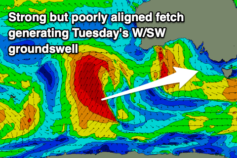
Instead some more tricky W/SW groundswell is expected off the earlier stages of this low, that being a strong but poorly aligned and poorly tracking polar front firing up towards Western Australia today and tomorrow. We'll see a great fetch of gale to severe-gale S/SW winds projected on the edge of our western swell window, possibly producing an inconsistent W/SW groundswell for Tuesday, peaking into the afternoon.
Winds will favour the Surf Coast and be persistent out of the N/NW with inconsistent sets reaching 2ft+, 4ft+ on the Mornington Peninsula. Winds will shift more N/NE and strengthen on Wednesday as the inconsistent W/SW groundswell eases.
Longer term, as touched on last updated we'll transition to a more reliable and normal setup with a couple of significant storms due to move in later week, generating some good quality groundswell for next weekend, but more on this Monday. Have a great weekend!
Comments
Pretty happy with that swell today, Craig. Busy but lots of waves around. Came in bigger than forecast. Cracker of a day too.
Good to hear! Rather be cautious on these swells than over forecast.
rippa day
Yes Bnkref. The swelled felt like it actually built during the day. Was biggest toward dusk at the island i reckon. Maybe because of the big high tide.