Great, fun weekend across most breaks, increased activity from late next week

Victoria Forecast by Craig Brokensha (issued Friday 17th May)
Best Days: Saturday, Sunday, Monday, Tuesday Surf Coast, later next week onwards Surf Coast
Recap
With Wednesday dropping a little quicker in size than expected I adjusted down the forecast for Thursday a touch, but the surf came in as expected on Monday with good easing 2-3ft sets on the Surf Coast, 3-5ft on the Mornington Peninsula with with light winds all day creating good to great conditions.
Today a new inconsistent SW groundswell has filled in with great clean 3ft surf across most breaks on the Surf Coast, with 4ft sets on the magnets, and 4-5ft waves to the east. The swell should hold most of the day as winds tend light E/NE-NE.
Today’s Forecaster Notes are brought to you by Rip Curl
This weekend and next week (May 18 – 24)
We've got a good weekend ahead for more exposed coasts and beaches with generally light winds from the northern quadrant and swells that won't over power these swell magnets.
 Today's inconsistent SW groundswell should ease back into tomorrow morning, but a new mix of W/SW and SW groundswell from a tricky trough and low combo are due to arrive in the morning.
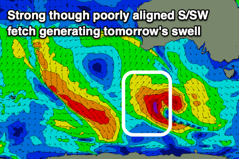
A weak fetch of W/SW winds south-west and under WA will produce a small mid-period W/SW swell, but a stronger though poorly aligned and short-lived fetch of S/SW gales on the edge of our south-western swell window should produce a better SW groundswell.
Size wise the Surf Coast should hold around 3ft on the magnets tomorrow, with 4-5ft sets to the east along with local offshore morning winds (N/NW to the west and N/NE to the east) ahead of SE sea breezes.
The surf should ease back into Sunday from 2-3ft and 4ft+ on the swell magnets across both coasts respectively along with a persistent N/NE'ly, favouring the beaches.
Into early next week a couple of new S/SW groundswells are due to fill in, generated by late forming polar lows in our swell window south-west of Tassie.
The first for Monday morning will be generated by a very late fetch of W/SW gales today, south-west of Tassie and should keep the Surf Coast around 3ft early, easing during the day, with 4ft+ sets on the Mornington Peninsula. A fresher N'ly tending N/NW breeze will favour the Surf Coast as the swell drops.
A stronger but not ideally aligned fetch of severe-gale to storm-force W/NW tending W/SW winds late in our southern swell window will produce a longer-period and slightly bigger S/SW groundswell for Tuesday morning.
The Surf Coast will likely be around 3-4ft, with 4-6ft sets to the east and a N/NW offshore will continue to favour locations west of Melbourne.
The surf should then ease into the afternoon and Wednesday, with a good new W/SW groundswell on the cards for Thursday and Friday. This swell will be generated by a broad and strong polar low projecting up from the Heard Island region towards and then under WA, generating a slow moving fetch of gale to maybe severe-gale W/SW winds.
A moderate to large long-period W/SW groundswell should build through Thursday and peak Friday to what at this stage looks to be 4ft on the Surf Coast and 6ft+ to the east. Winds are a little unsure, but look to be from the western quadrant and beyond this the Southern Ocean looks to start to fire up, bringing back to back groundswell events. More on this Monday, have a great weekend!
Comments
Craigos, loving how early the forecaster notes are getting uploaded at the moment. Wizardly work getting it up by 10am, keep it up Mr No Sleep!
Well I try and crack them out before heading off for a mid-late morning surf ;)
Keep it clean, Craig.
Gary is almost certain that none of the kids reading SN want to hear about you regularly cracking one out before your mid morning surf
That's where you have it wrong Gazza! They boys would much rather hear about Craigos rubbing one out than a 4-5ft offshore Sunday on the beaches
South Channel is full of shit. NNE there but NNW on the back beach. Why does this coast try its hardest to fuck up.
It blows over a tiny strip of land in a good direction, sees the back beach and goes “I wanna go this way now.”
I feel your pain, ha.
Well it was super light n/ne over here NB and it put some small ribs on the face.
There's some nice albeit, slow swell underneath though and the next 3 day look much better for you guys.
I like this time of year..
Solid at 13th, MP must be pretty big?
Yeh too big apart from a few very crowded locations
Depends where you look geek!
Yeah looks like that tricky swell from the gales around the low punched above it's weight!
Yep, was excellent all day, straight n powerful when those set's came through. Wasn't expecting much so it was a nice surprise.
Was fairly solid at 13th this morning on the sets. Super heavy fog though. Couldn’t see a thing.
What about later in the day? Must have been throwing?
Would have been on but i was just down there for the dawn patrol. Really good there this morning.
Just for the record...
a 3m swell in port Campbell is a bit bigger than a 3m swell near Coffs Harbour. Today was an eye opener! Do you southerner know how good you’ve got it?
PC is a zone not to be mentioned my friend, keep it to yourself and enjoy it!