Very average outlook

Victoria Forecast by Craig Brokensha (issued Friday 3rd May)
Best Days: No good days
Recap
A small and inconsistent W/SW swell yesterday to 1-2ft on the Surf Coast and a better 3-4ft on the Mornington Peninsula with favourable winds all day for the beaches. This morning the swell was a similar size though with a shift to NW winds, favouring the Surf Coast.
Today’s Forecaster Notes are brought to you by Rip Curl
This weekend and next week (May 4 – May 10)
With an initial downgrade in the swell due over the weekend from a tricky and broad multi-centred mid-latitude low, we've now got a slight upgrade on the cards with a better and more prolonged fetch of strong SW winds due to be aimed up and into us today and tomorrow.
The fetch will bring a SW change early-mid morning tomorrow (W'ly early on the Surf Coast but with no size), with building surf to 3ft+ across the Surf Coast into the afternoon and 4-5ft+ on the Mornington Peninsula. Conditions will be very average though with the SW wind.
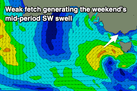 Come Sunday we'll see the mid-period SW swell easing as winds linger from the S/SW, creating average conditions. Expect dropping surf from 2ft to possibly 3ft on the Surf Coast and 4ft on the Mornington Peninsula.
As touched on last update there's nothing significant at all on the cards for next week as the mid-latitude low linked to the weekend's swell deepens in the Tasman Sea. This will put a temporary block across our swell windows before a couple of strong cold fronts try and push in across the country early next week.
As they do so they'll weaken and not bring any decent swell with them. Tricky mid-period W'ly swell pulses are on the cards from mid-late week, with a long-period signal in the mix on Thursday.
The long-period signal will be generated by a good mid-latitude front pushing through the Indian Ocean towards WA, poorly through our western swell window.
Size wise the Surf Coast isn't likely to see anything over 1ft Thursday, with the Mornington Peninsula possibly seeing very infrequent 2ft to maybe 3ft sets. Winds look poor for exposed beaches though as a stronger cold front moving in later week brings strengthening N/NW winds ahead of an afternoon W/SW change.
Behind this front some better swell is likely but the models diverge on the outlook into later next week and weekend, so check back here Monday for more info. Have a great weekend!
Comments
Well the crew over at Rip Curl must have had a serious sacrifice, sold a soul, or something because it's gonna be really shit for a while now by the looks of it. Come on Autumn, do ya thing, bring on the cold, wind and rain, I love that hectic weather.
I'm with you G. Bring on the Autumn and Winter swells. That's when Vicco surf comes alive. Plus I've got my new 6mm Need Essentials booties I want to try out. Water needs to cool down a fair bit first though.
6mm! Fuck doesn’t that feel like surfing with Blundstones on your feet?
Winter is stalling itself so be prepared when it kicks in proper, its gonna drop a fuckin hammer on us
Bird man has some hunger
What a stinker of a forecast!
Craig, are you seeing more meridonal weather patterns in the Vic forecast area? Things that feel like season switch on/season switch off?
Way back when I was a teen, I cut the synoptic out of the West Australian and compiled a book of it, with surf notes for each day, for 1993. Looking back then, yes, you got those big Australia wide blocking highs, yes, a more extreme front would follow a high that got a long way south, yes you would get periods of lots of fronts (I didn't know about the LWT at this time) and periods of not much. Is this changing, or are we reporting and sharing these changes more?
I do note extremes lately like snow to ground level in Morocco, Saudi, Israel, Syria; earliest snow season in Hokkaido history, birkeland currents becoming visible for first time in recorded history ("Steve"), etc; and see the NHemi being much more meridonal (US going from hot to frost, coldest ever temps recorded around the Great Lakes), Hell freezing over (Hell, Michigan) and wonder if we're getting the same here in our passage of fronts?
As we are all realising, it's bringing more extreme big waves :)
Global warming mate
Hey VJ, hard to say, but the southern states go through these patterns when we have the lows forming in the Tasman and off the East Coast.
thx, it's taken me about this long to suss out that when this pattern happens, it's probably better to drive over to certain rivermouth bars in the land of stop-start rugby...
Friday onwards looks interesting. Sustained run.