Hot, small weekend, strong swell event next week

Victoria Forecast by Craig Brokensha (issued Friday 1st March)
Best Days: Exposed beaches tomorrow and Sunday morning, both coasts Tuesday morning, Surf Coast early Wednesday, Thursday
Recap
Clean fun waves on the beaches yesterday, best east of Melbourne while today the swell has backed right off to an inconsistent 1-2ft on the magnets with a hot offshore wind.
Today’s Forecaster Notes are brought to you by Rip Curl
This weekend and next week (Mar 2 - 8)
The weekend will be mostly clean and hot with persistent offshore winds from the northern quadrant and small fun surf on the exposed beaches.
An inconsistent new SW groundswell should fill in tomorrow, generated earlier this week on the polar shelf, with not much size expected on the Surf Coast magnets above 2ft on the sets, 3ft+ to the east.
The morning high tide will likely swallow a bit of the energy so there's no rush for the early. Winds should be locally offshore out of the N/NW on the Surf Coast, N/NE on the Mornington Peninsula and most likely persisting into the afternoon.
Sunday looks to see similar winds, though giving into a shallow change later afternoon and into the evening and the swell will be on the ease. Fading 1-2ft sets are expected on the Surf Coast with easing sets from 3ft on the Mornington Peninsula.
 Monday morning looks average with onshore SW winds due across most locations in the wake of Sunday's change, and a new building W/SW swell isn't expected to offer much size until the afternoon. The Surf Coast may see a dawn W'ly but be small and to a very infrequent 2ft, with the afternoon seeing possibly 3ft sets, with the Mornington Peninsula building to an inconsistent 4-5ft.
This swell has been generated by a distant frontal system south-west of WA resulting in the small and inconsistent nature.
Tuesday looks better with a variable tending NW breeze creating clean conditions across most beaches as the W/SW swell eases. The Surf Coast will be small and easing from 2ft, with 4ft sets to the east.
Of greater importance is our moderate to large long-period W/SW groundswell due mid-late week.
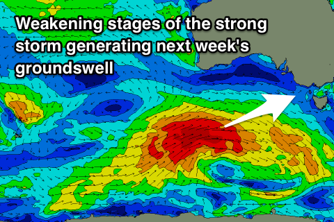
A powerful low will form north of the Heard Island region this evening, with a small tight fetch of severe-gale to storm-force W'ly winds due to project east through our far western swell window, broadening in scope south-west of WA Sunday evening.
The low is expected to weaken south of the country Monday but still generate a broad and elongated fetch of W/SW gales in our western swell window before spawning a weak cold front. This front will project up and into us through Wednesday bringing a building mid-period W/SW swell, ahead of the groundswell proper into the afternoon, peaking overnight and easing Thursday.
Size wise the Surf Coast should build through the day Wednesday and reach 4-5ft by dark, with 6-8ft sets to the east along with an early W/NW offshore ahead of a SW change as the front moves through.
Another front pushing in from the west will likely swing winds back to the N/NW on Thursday as the swell eases from a similar size across both coasts.
Longer term the models diverge on the strength of the secondary frontal activity but in any case we should see additional swell events later week and into next weekend, but more on this Monday. Have a great weekend!
Comments
Excellent................!
Wed - “At this stage the Surf Coast looks to come in at a strong 3-5ft, with 6ft+ sets to the east though with winds from the east to north-eastern quadrant. This is a long way down the track though so we'll review it and a possible bigger follow up swell next weekend on Friday.”
Today - “Another front pushing in from the west will likely swing winds back to the N/NW on Thursday as the swell eases from a similar size across both coasts.”
“Here ya boys and gals. A nice swell with a NE. PSYCH!!! Fuck you MP. I fucking hate you.” - Huey.
Haha well those second fronts weren't there on Wednesday, winds look favourable at this stage for your region Nick..
Just using your quotes as reference Craigo mate, the winds aren’t under your control..
Or are theyyyyyy???