It's all about the beaches

Victoria Forecast by Craig Brokensha (issued Monday 25th February)
Best Days: Exposed beaches Wednesday AM, Thursday AM, Saturday, keen surfers Sunday AM
Recap
Average conditions across all locations on Saturday with a drop in size, better on the beaches Sunday with easing 3ft sets on the Mornington Peninsula and Phillip Island, still average to the west.
Today the surf has bottomed out with tiny clean waves across all locations.
Today’s Forecaster Notes are brought to you by Rip Curl
This weekend and next week (Feb 26 – Mar 3)
As touched on last update, the coming week isn't too special surf wise on the Surf Coast, but the beaches are looking fun Wednesday and Thursday.
Tomorrow will be another lay day with the swell remaining small to tiny along with onshore S'ly winds, freshening through the day as a surface trough followed by a high pressure system move in from the west.
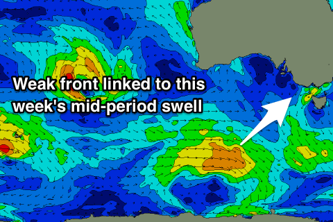
Later in the day a new mid-period SW swell should start to build, generated by a broad but weak storm south-west and south of WA over the weekend. A persistent fetch of strong W/SW winds were generated in our western and then south-western swell windows, producing a fun swell for the beaches.
 A peak in swell is expected through the day Wednesday and we should see the Surf Coast building to 2ft+ with the chance of the odd 3ft set at magnets, with 3-4ft+ sets on the Mornington Peninsula. Winds will be best for the beaches to the east of Melbourne with an E/NE offshore, tending SE through the afternoon.
Thursday will be nice and straight across most beaches with a fresher N/NE offshore, persisting most of the day but with small easing 2ft sets on the Surf Coast, 3ft+ to the east.
Friday should be nice and clean again with local offshore winds but we'll reach another low point in swell, tiny on the Surf Coast and 1ft to maybe 2ft on the Mornington Peninsula.
The weekend is looking like another OK one on the beaches with distant and inconsistent pulses of groundswell along with a straight N'ly wind Saturday, similar Sunday as a surface trough lingers across the state.
The best pulse of SW groundswell for Saturday morning will be generated by a less than favourably aligned but strong polar front dipping east-southeast through our swell window mid-week. A polar fetch of gale-force W/NW winds will be generated, with the swell peaking Saturday morning to 3ft+ on the Mornington Peninsula but only a small 1-2ft on the Surf Coast. Sunday will then be smaller, tiny on the Surf Coast and 2ft to maybe 3ft on the Mornington Peninsula if we're lucky and easing.
Longer term we'll likely see a continuation of favourable winds but no significant swells, best on the beaches. More on this Wednesday.
Comments
Tonight down in far west vic there was like this reddy particle shit in the water with sorta a bit of foamy stuff around and it heated up the water temperature to like a warm bath. Anyone know what it is??
potential red tide algal bloom, surf coast had it briefly back in december
Yep that's red tide, an algal bloom and as you said the warmer is usually warmer around where it's converging. There are also usually nasty little sea lice in it as well.