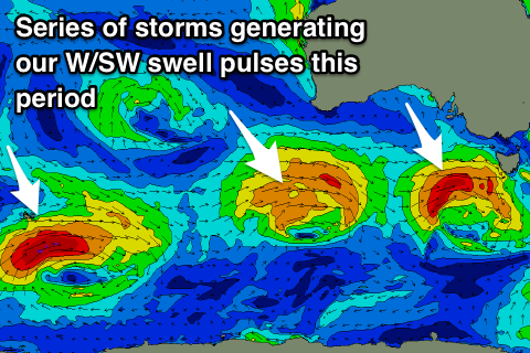
Back to back swells pulses with workable winds

Victoria Forecast by Craig Brokensha (issued Friday 28th December)
Best Days: Exposed beaches before the change tomorrow, keen surfers Sunday and Monday, Surf Coast Tuesday morning, Wednesday and Thursday mornings
Recap
Good fun waves across all locations yesterday with a new W/SW swell and light offshore winds coming in at 3ft on the sets on the Surf Coast and 3-4ft on the Mornington Peninsula.
Today the swell has eased leaving full and slow 1-2ft waves on the Surf Coast (more to 2ft at 13th Beach) and 2-3ft on the Mornington Peninsula and Phillip Island. An onshore change is due by late morning (just hit Aireys Inlet) so try and get in a paddle now.
Today’s Forecaster Notes are brought to you by Rip Curl
This weekend and next week (Dec 29 – Jan 3)
Tomorrow morning will be the best time to get a surf in over the weekend, but you'll be fighting the high tide and an approaching change that's due in mid-late morning.
A small new SW swell is due off a weak front that moved under the country mid-week, with small 2ft sets due at Surf Coast swell magnets, and 3-4ft sets on the Mornington Peninsula.
Conditions should be clean early with a light variable wind, but a shallow SW change is due mid-late morning.
A better W/SW swell is expected into Sunday, with a further upgrade in the strength of this system into today.
A mid-latitude front is currently passing under the south of WA, with a good fetch of strong W/SW winds being generated in our western swell window.
The front will dip east-southeast while tightening and strengthening, producing a fetch of W/SW gales through our swell window before dipping across Tassie tomorrow afternoon.
 A fun pulse of W/SW swell should be seen Sunday coming in at 3ft on the Surf Coast swell magnets and 4-5ft to the east, but conditions will be bumpy with a moderate southerly wind. Keen surfers will still find some OK options.
The swell will drop into Monday morning ahead of a new W/SW swell building through the day, produced by another mid-latitude front projecting at a more favourable southerly latitude. Winds will only be strong, with the Surf Coast expected to kick back to 3ft into the afternoon, 4-5ft on the Mornington Peninsula though with light to moderate S/SE winds.
Tuesday looks cleaner on the Surf Coast as winds swing back to the W/NW through the morning with smaller easing 2-3ft waves, 3-5ft and bumpy on the Mornington Peninsula.
As talked about in Wednesday's update, a slower moving and broader frontal progression through the weekend and early next week should produce a prolonged mid-period W/SW tending stronger SW groundswell event.
An increase in size is due through Wednesday with a peak expected overnight, easing slowly Thursday.
Size wise the Surf Coast should build gradually Wednesday and reach 3-4ft by dark, with 5-6ft sets to the east. Thursday looks similar in size, if not for the possible bigger set at dawn but local winds are a little unsure at this stage. There's some model divergence but Thursday morning is looking clean at least across one region, check back here Monday for a clearer idea. Have a great weekend!