Clean small end to the week, swell but onshore from the weekend

Victoria Forecast by Craig Brokensha (issued Wednesday 5th December)
Best Days: Exposed beaches tomorrow morning, desperate surfers Monday and Tuesday morning
Recap
Good waves on the Surf Coast reefs again yesterday morning with slowly easing sets from 3-4ft, large and only good in protected spots to the east.
This morning the Surf Coast was better than expected with winds light enough to not cause too much damage, along with good surf around 3ft, fun to the east and improving through the morning with 3-5ft sets. We'll see the swell continue to drop this afternoon with sea breezes across all locations.
Today’s Forecaster Notes are brought to you by Rip Curl
This week and weekend (Nov 6 - 9)
The outlook for the end of the week isn't too flash, but the exposed beaches across the state will be the pick through tomorrow.
We'll see the swell continuing to ease, dropping back from 2-3ft on the Mornington Peninsula tomorrow morning, while the Surf Coast will be small to tiny and 1ft to maybe 2ft on the magnets.
A moderate to fresh N/NE wind should persist all day as the swell drops, while come Friday the surf will be tiny though clean with a gustier N'ly offshore, tending N/NW mid-late afternoon ahead of an evening SW change.
 Later in the day and more so Saturday we should see a new acute W'ly swell filling in, generated the last couple of days by a slow moving but poorly aligned storm west-southwest of WA.
As the swell builds late Friday conditions look bumpy with that change, and come Saturday winds will increase from the SW, creating poor conditions. The Surf Coast may see an early W'ly breeze, but size wise we're not expected to see much over a very inconsistent 2ft across protected spots, possibly up to 3ft at times across magnets, but wind affected. The Mornington Peninsula looks average and around the 4ft range.
Sunday will be poor across all locations as the swell eases under a fresh S'ly breeze.
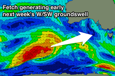
As touched on last update, we're due to see a stronger but inconsistent W/SW groundswell filling in early next week
This will be generated by a strong polar front developing around the Heard Island region and projecting a fetch of W/SW gales slowly up towards and then under WA while weakening.
The swell should arrive overnight Sunday and peak Monday to a better 3ft on the sets across the Surf Coast and 4-5ft+ to the east, but winds look to remain onshore out of the S'th, spoiling conditions.
More favourable winds may be seen on Tuesday as the swell eases, but the models diverge on this while more E'ly winds are likely from mid-week but with no real size left.
Longer term smaller W/SW swells are on the cards with persistent easterly winds, but more on this Friday.