Easing surf as winds swing around the clock

Victoria Forecast by Craig Brokensha (issued Monday 3rd December)
Best Days: Surf Coast Tuesday morning, beaches mid-late morning to early arvo Wednesday, desperate surfers beaches early Thursday
Recap
Fun though inconsistent waves across both regions on Saturday with a new W/SW groundswell and favourable winds for both the beaches and selected reefs on the Surf Coast.
Yesterday morning started slow with a low point in swell, but our late kick in new W/SW groundswell was seen to 4-5ft across Bells and Winki, though bumpy and windy.
The swell has peaked this morning and is coming in at a solid though windy and tricky and inconsistent 4-6ft on the Surf Coast, with larger messier 6-8ft sets to the east.
Today’s Forecaster Notes are brought to you by Rip Curl
This week and weekend (Nov 4 - 9)
The large W/SW groundswell seen this morning was generated by a strong slow moving low over the weekend. This swell peaked early this morning and will start easing this afternoon, but a secondary front developing on the back of the low is currently pushing in, responsible for today's strong and tricky offshore winds.
This should generate a reinforcing SW swell for this evening, backing off through tomorrow, much weaker in energy and smaller in size.
The Surf Coast should ease back from the 4ft range, with 6ft sets to the east, smaller and down from 2-3ft at magnets Wednesday morning, 3-4ft+ on the Mornington Peninsula.
Winds tomorrow will be favourable for the Surf Coast most of the morning and out of the W/NW, shifting W/SW later morning-midday, while a shift in winds to the E/NE-NE through the morning Wednesday will favour the beach breaks. This will create improving conditions mid-late morning ahead of the sea breeze.
 Thursday is still looking great for the beaches wind wise with a N/NE offshore, but there'll be only minimal levels of swell left, dropping back from 2ft to maybe 3ft, small to tiny on the Surf Coast.
A low point in swell is expected Friday morning as a surface trough approaches from the west bringing variable winds (offshore from the N'th early).
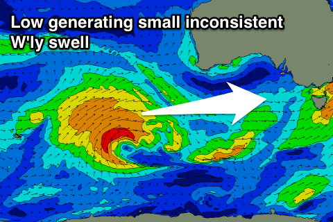
A small inconsistent W/SW swell is due into the afternoon and more so Saturday, produce by a broad, slow moving but relatively weak frontal system that's currently west-southwest of WA.
The swell will be very west for the Surf Coast and only likely provide an inconsistent 2ft waves at most breaks, possibly up to 3ft on the magnets, but a long wait for them, while the Mornington Peninsula should offer inconsistent 4ft sets.
We may see winds shifting S/SW and strengthening through Saturday though as the surface trough moves east, with small easing surf and S/SE winds on Sunday.
Longer term another inconsistent W/SW groundswell is due early next week with a possible improvement in local winds, but check back here on Wednesday for more on this.
Comments
Spot-on forecast for the swell today Craig, the swell was still around 3ft but much weaker and the early high tide made it feel more like a wind swell as they wobbled their way to the shore. That wind has been fluking around pretty early this morning as well but luckily only light.
Yep. Felt like half the size and power of Sunday night. Still some fun ones about though. And it is December.