Good swell wrecked by onshores, improving from Sunday

Victoria Forecast by Craig Brokensha (issued Wednesday 14th November)
Best Days: Keen surfers Friday morning with low expectations, Sunday morning beaches, Monday beaches
Recap
A drop in swell through yesterday but fun and clean across most locations through the morning, bumpier on the beaches to the east with a strengthening N'ly wind ahead of a late onshore change.
This morning winds were onshore across all locations with small levels of swell creating average conditions.
Today’s Forecaster Notes are brought to you by Rip Curl
This week and weekend (Nov 15 – 18)
The surface trough linked to today's onshore winds will push further east tomorrow as a high ridges in from the west and with this we'll see poor conditions continue.
A fresh and gusty S/SW breeze is due through the morning, tending more S'ly if not S/SE later in the day, with our new SW groundswell filling in through the day.
 The final touches are still being added to this swell, with a strong polar low currently south-west of Tassie aiming a fetch of W/SW gales through our south-western swell window.
Size wise the swell will be more W/SW and small tomorrow morning, with the most size arriving through the afternoon and out of the SW.
Surf Coast swell magnets should build to a consistent 3ft, with the odd 4ft set, with 4-6ft waves on the Mornington Peninsula.
The swell is due to start easing through Friday and we're now looking at a possible small window of cleaner conditions as another small trough moves through the area.
This is expected to bring light and variable winds from the SE ahead of a freshening S/SW'ly through the afternoon. With this conditions won't be great bit will likely be better than tomorrow. The Surf Coast should ease back from 3ft+ with 4-5ft sets to the east.
Saturday will be poor again under a fresh S'ly tending S/SE breeze.
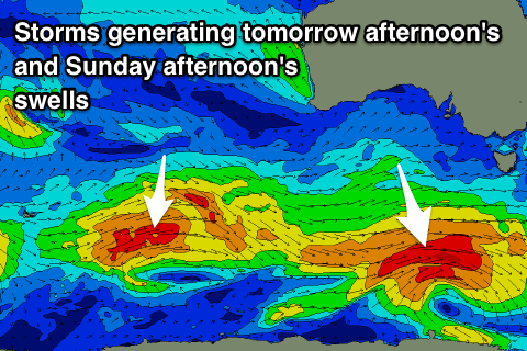
We've still got our inconsistent mid-period pulses of swell due over the weekend, the first for Saturday with a secondary pulse for Sunday, more so the afternoon and Monday morning.
As touched on in Monday's notes, they'll be generated by fetches of strong to gale-force W/SW fetches in our far swell windows south-west of WA, with weaker fetches of strong W/NW winds moving in closer to us, south-west of Tassie on Friday.
Size wise the Surf Coast should hold around 2ft+ on Saturday, with 3-4ft sets on the Mornington Peninsula, similar Sunday morning though building into the afternoon to 2-3ft and 3-5ft respectively.
Winds should start to improve on Sunday for the beaches and tend NE through the morning ahead of afternoon sea breezes.
Monday will be clean again with a N/NE offshore, likely holding into the afternoon. Size wise Sunday afternoon's swell is expected to ease, small and inconsistent into Tuesday. We'll have another look at this Friday though.