Strong groundswell building through the weekend, easing into next week

Victoria Forecast by Craig Brokensha (issued Friday 9th November)
Best Days: Late morning through eaarly afternoon Sunday, beaches Monday and Tuesday
Recap
Great waves on the Surf Coast reefs again yesterday with a reinforcing mix of mid-period W/SW and SW swell to 3-4ft, larger but bumpier to the east.
This morning the swells are on the ease with clean conditions across both the beaches and reefs on the Surf Coast, a little average still but better on the Mornington Peninsula beaches. We'll see the swell continuing to ease as winds tend W/NW.
Today’s Forecaster Notes are brought to you by Rip Curl
This weekend and next week (Nov 10 – 16)
Compared to last weekend, this one is looking a little hit and miss.
Tomorrow will be clean again on the Surf Coast but the swell will be on its last legs, dropping back from a small 2ft on the magnets with a W/NW-NW offshore, tending W/SW around midday and SW into the afternoon.
 A low point in swell is still expected on Sunday morning with a light and variable wind. The Surf Coast is likely to be tiny with a small 2ft+ wave on the Mornington Peninsula, but our strong new long-period SW groundswell is set to arrive later morning and build strongly into the afternoon.
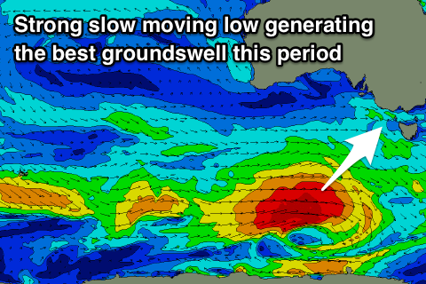
A strong polar low formed south-west of WA yesterday, with an initial small and fast moving fetch of severe-gale to storm-force W'ly winds now slowing and broadening.
We're seeing a great fetch of gale to severe-gale W/SW winds generated south of the country, with the low expected to push slowly east-southeast and out of our swell window tomorrow morning.
The swell should build to an easy 4ft into the late afternoon across most breaks on the Surf Coast, 5ft on the sets at magnets, with 6ft to occasionally 8ft sets on the Mornington Peninsula though SE sea breezes will create bumpy conditions.
Monday looks much better as the SW groundswell eases back from 3-4ft and 5-6ft respectively under a N/NE offshore wind, favouring the beaches. Winds may hold into the afternoon, but it's a bit hard to be confident on this three days out. In any case there'll be plenty of time to get at least two surfs in before a possible sea breeze kicks in.
Tuesday will be smaller again but good across the exposed beaches again with a N/NE offshore and easing 2ft+ sets on the Surf Coast, 3-4ft on the Mornington Peninsula.
Our next increase in swell looks to arrive through Wednesday afternoon and peak Thursday, coming out of the W/SW.
This will be generated by a persistent fetch of pre-frontal strong to gale-force W/NW tending W winds moving in from the south-east Indian Ocean and under WA before dipping south-east away from us.
A secondary front may piggy-back on the back of this front generating a secondary pulse of W/SW groundswell for Friday.
We'll have to have a closer look at this Monday but at this stage 3ft to maybe 4ft waves are expected on the Surf Coast and surf in the 6ft range to the east but with onshore S'ly winds as a strong high moves in behind the secondary front on Wednesday. Check back Monday for an update and have a great weekend!