Fun end to the week on the Surf Coast, upgrade in weekend swell

Victoria Forecast by Craig Brokensha (issued Wednesday 7th November)
Best Days: Surf Coast Thursday morning and Friday, locations to the east Sunday and Monday mornings
Recap
Another pumping morning of waves across the Surf Coast yesterday as a large long-period SW groundswell filled in, providing 6ft+ sets across the magnets with the rare bigger clean-up, while the Mornington Peninsula was 6-8ft and clean all day with variable winds.
This morning the swell had dropped back to 3-4ft on the Surf Coast and conditions are again great on the reefs, bumpy and average to the east. Only a slight drop in swell is expected this afternoon, but the energy will drop a bit with some new reinforcing swell only being mid-period. Winds will swing W/SW around midday.
Today’s Forecaster Notes are brought to you by Rip Curl
This week and weekend (Nov 8 – 11)
We're now on the backside of the large run of groundswell since the weekend, but in saying this, the Surf Coast will continue to offer super fun waves into the end of the week.
Mid-period W/SW and SW swells will fill in later today and hold most of tomorrow, generated by broad but relatively weak fetches of strong W/SW-SW winds through our swell windows the last couple of days.
The Surf Coast should hang around 3ft with the odd 4ft'er at times through the day, 5-6ft on the Mornington Peninsula.
Winds look to hold a little longer out of the W/NW across the Surf Coast tomorrow morning, likely until late morning and then shifting W/SW-SW, while Friday looks great as the swells ease from 3ft on the sets across magnets on the Surf Coast, 4-5ft to the east with a NW tending W/NW breeze.
 Saturday will be clean again with a NW offshore through the morning but the swell will be small and only to 2ft, bumpy and 3-4ft to the east with onshore SW breezes into the afternoon.
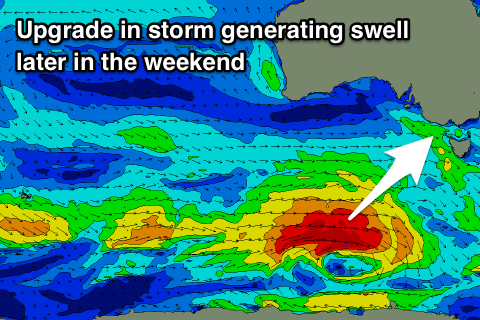
Moving into Sunday the surf will start slow and small, but we've had an upgrade in the swell due into the afternoon with an earlier arrival time.
This swell will be generated by a polar front that will develop south-west of WA this evening and project a fast moving fetch of severe-gale W'ly winds initially, slowing down slightly south-west of us on Friday and broadening a touch before breaking down.
A moderate to large sized long-period SW groundswell should be produced, arriving around midday Sunday and building strongly into the afternoon.
The Surf Coast should reach an easy 4ft, with 5ft sets on the magnets before dark, with 6ft+ waves on the Mornington Peninsula.
A peak is expected overnight with easing surf from 3ft to maybe 4ft and 5-6ft respectively Monday.
Winds on Sunday at this stage are a bit suss with a small surface trough drifting in from the west. This will likely result in morning variable breezes, freshening from the SE into the afternoon as the new swell kicks in.
Monday is unsure as the models diverge on another trough moving in from the west, swinging winds back to the NE. If this doesn't happen we'll likely see less ideal E'ly winds. More on this and the swell on Friday.