Better swells ahead with varying winds

Victoria Forecast by Craig Brokensha (issued Monday 29th October)
Best Days: Surf Coast tomorrow morning, both locations Wednesday morning for keen surfers, beaches Thursday morning, Surf Coast early Friday and Saturday and then Sunday morning
Recap
Besides a small clean 1-2ft wave in protected spots on the Surf Coast Saturday morning, the weekend was generally poor with onshore winds and weak small swells.
Today an inconsistent SW groundswell has provided a slight increase in size but winds remain onshore and average across all locations.
Today’s Forecaster Notes are brought to you by Rip Curl
This week and weekend (Oct 30 – Nov 4)
Tomorrow's better SW groundswell is still on track, with a good pre-frontal fetch of NW gales developing Friday producing a W/SW groundswell followed by post-frontal and polar strong to gale-force W/SW winds, helping generate a more favourably aligned SW swell.
We should see some stronger size showing later today with a peak tomorrow coming in around 3ft on the Surf Coast and 4-5ft on the Mornington Peninsula. There's a chance for the odd sneaky bigger one, but it will be mostly around these sizes.
Conditions will be best for the Surf Coast with a light NW offshore wind, tending variable ahead of SE sea breezes. Locations to the east should improve a touch later morning as winds tend variable and ahead of the sea breeze.
The swell should drop temporarily into Wednesday morning ahead of a new long-period W/SW groundswell arriving later morning and peaking into the afternoon.
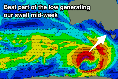 This swell is being generated by an intense but small low that's pushing in from well south of WA.
Last week this low was forecast to be broader but instead it's a tight system generating a concentrated fetch of severe-gale W'ly winds, weakening while moving closer towards us but in an east-southeast direction.
The storm will expand a little in scope through our south-western swell window, with a long-period W/SW tending SW groundswell due to fill in Wednesday and reach 3-4ft on the Surf Coast and 5-6ft on the Mornington Peninsula into the afternoon.
Conditions are looking less than ideal with only a light variable wind due Wednesday morning leaving a fair bit of lump, while it will be bumpy with sea breezes as the new swell fills in proper.
Thursday morning looks much better as winds tend NE-N/NE through the morning with plenty of good sized sets, easing back from 3ft+ and 4-5ft+ respectively at magnets on both coasts, slowed slightly by a weak front on the tail of the strong low.
A shift in winds to the NW is expected on Friday morning as a strong storm approaches from the south-west, bringing an afternoon W/SW change. Size wise the Surf Coast will be cleanest but small and easing from 2ft+.
The approaching storm will originate from a strong polar front projecting towards WA, pushing further east under the Bight while generating a fetch of W/SW gales, and then possibly strengthening further directly south-west of us Friday.
ECMWF has a slightly weaker intensification but in either case we'll see at least a moderate sized W/SW tending SW groundswell generated for Saturday, building through the day but with onshore W/SW winds (possibly W/NW around Torquay). We'll likely see a high move in behind the front on Saturday bringing NW offshores as the swell eases, but we'll have a closer look at the size and winds on Wednesday.
Longer term there's another follow up swell due early next week, but more on this Wednesday.