Clean easing surf, poor weekend

Victoria Forecast by Craig Brokensha (issued Wednesday 29th November)
Best Days: Exposed beaches across the state tomorrow, possibly early next week
Recap
After kicking later Monday, our new SW groundswell provided good 3ft sets on the Surf Coast with light winds most of the day and super fun waves. The Mornington Peninsula offered 4-5ft sets and conditions improved through the day ahead of mid-late afternoon sea breezes.
This morning a reinforcing SW swell, mixed in with some SE windswell has provided peaky 2-3ft waves on the Surf Coast, while the Mornington Peninsula was pumping with clean 3-5ft surf. We should see the swell start to ease back through the day as sea breezes kick in through the afternoon.
Today’s Forecaster Notes are brought to you by Rip Curl
This week and weekend (Nov 30 – Dec 3)
This morning's reinforcing SW groundswell should start easing through the day, and moving into tomorrow, the Surf Coast isn't due to offer much size with easing 1-1.5ft sets, while the Mornington Peninsula should see easing 2-3ft sets.
Conditions will be great for exposed spots with a N/NE offshore wind, tending variable mid-afternoon ahead of possible late sea breezes. By then though the swell will be small to tiny.
Friday isn't worth worrying about with the swell bottoming out (1-2ft max Mornington Peninsula) along with morning variable winds ahead of gusty S/SW change as a surface trough moves in from the west.
Now, the models were divergent on the strength and longevity of this trough, but we're now getting some consolidation.
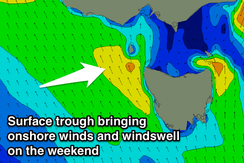 This trough is expected to be angled more south-east to north-west resulting is no major windswell and poor onshore winds Saturday out of the S/SE-SE, persisting Sunday.
Some small weak windswell is expected across both regions through the weekend, but not above 2-3ft on the Surf Coast and similar on the Mornington Peninsula.
Some small background S/SW swell should also be in the mix, but only to 1-2ft on the Surf Coast Sunday morning and 2-3ft on the Mornington Peninsula.
As we move into next week, onshore winds should ease, with hopefully variable winds Monday morning along with a new SW groundswell.
This swell will be generated by a strengthening polar storm drifting in from the west later this week, producing a pre-frontal and post-frontal fetch of strong to gale-force winds.
The swell is due to build through Monday, reaching a peak in the afternoon to 2ft+ across the Surf Coast and 3-5ft on the Mornington Peninsula though with sea breezes.
A drop in size is due Tuesday though winds are still a little unsure. Check back Friday for more on the outlook for next week.
Comments
With the seabreeze and gradient winds. Would the more to the west and stronger winds more likely to hold the sea breeze at bay?
Would fresh Easterlies give way for fresh seabreezes as they travel along the same synoptic path?
Yep, though if those easterly winds reach a certain strength in the upper atmosphere, they'll override the sea breeze. Generally they'll enhance it though.
Upper atmosphere 10hPa shows a pretty strong easterly between NZ and East Coast Aus - is that what's driving this long period of easterlies, small swell and (at times) humidity in Vic?
Also, with La Nina in progress, does that tend to guarantee an all-time season for NE-E swell in NSW and QLD?
Same crap. Different month.
For those who can't surf mornings that is.
Serenity now!
Don't worry too much pal. I can surf every morning and it's been a pile of shit on the S.C virtually every one of those mornings since early October. Find something else to do or drive a loooong way East or West of here.
Incoming: Vic rain event:
http://forum.weatherzone.com.au/ubbthreads.php/topics/1442290/Vic_potent...
http://www.abc.net.au/news/2017-11-29/thunderstorm-warning-issued-for-vi...
Not to think it from the last week or so, but almost time to dust off the 3/2 with the fluffy inner stuff for after the temp drops 20 degrees...
Is this La Nina-ish?