Fun swell for exposed breaks Wednesday/Thursday

Victoria Forecast by Craig Brokensha (issued Monday 20th November)
Best Days: Swell magnets Wednesday morning, Thursday morning and Friday morning
Recap
Small peaky waves over the weekend with a mix of SE windswell and background SW groundswell energy. There was no major size or push to the surf but light winds each morning created favourable conditions.
This morning the surf was smaller and weaker with variable winds across all locations again.
Today’s Forecaster Notes are brought to you by Rip Curl
This week and weekend (Nov 21 - 26)
Tomorrow will remain tiny to small with a weak mix of swells though conditions will be great across exposed beaches with a light morning N/NE breeze ahead of sea breezes.
Moving into the middle of the week and more so Thursday, our new pulses of W/SW groundswell are due. The first pulse for Wednesday morning will only be small, generated by an initial fetch W/SW gales at the head of a stalling low, south-west of WA over the weekend.
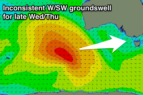 This swell is only due to provide infrequent 1-2ft waves on the Surf Coast through the morning, with 2-3ft sets on the Mornington Peninsula, though a stronger increase is due into the late afternoon and more so Thursday morning.
This was produced by a secondary fetch of W/SW gales wrapping around the back of the low, on top an active sea state.
Stronger but infrequent 2-3ft sets are likely on dark across the Surf Coast Wednesday, with 4-6ft sets on the Mornington Peninsula, with a peak Thursday morning to 3ft on the sets across the Surf Coast magnets exposed to the west swell and 5-6ft on the Mornington Peninsula.
Due to the large distance between the source of the swell and our region, there'll be long waits between the bigger sets.
Coming back to the winds, and Wednesday morning should see similar morning N/NE breezes ahead of sea breezes, while Thursday looks good as well with local morning offshore winds ahead of SE sea breezes.
The swell will ease through Thursday afternoon, back further Friday from a small 2ft max at magnets on the Surf Coast and 3-4ft on the Mornington Peninsula with favourable winds.
Longer term there's nothing major due into the weekend besides a small pulse of SW energy Saturday morning from a very short-lived and small low firing up late in our swell window. We should see some better swell early next week, but more on this Wednesday.
Comments
Hi Craig, I'd like to place an order for 3-4ft on the reefs, N to NW wind and a bit of cloud on the side, cheers.