Clean easing surf, new W/SW swell late week

Victoria Forecast by Craig Brokensha (issued Monday 16th October)
Best Days: Both coasts Tuesday (more so beaches east of Melbourne), keen surfers early Wednesday at magnets east of Melbourne, Surf Coast early Saturday and Sunday morning
Recap
Fun waves across the Surf Coast Saturday morning with a good new SW groundswell pulse along with light winds from the western quadrant, favouring the protected reefs.
A reinforcing S/SW pulse kept sets up around 3ft yesterday morning on the Surf Coast with 3-5ft waves on the Mornington Peninsula along with light local offshore winds before weak sea breezes kicked in.
Today a reinforcing SW swell has come in a bit better than expected with good 3ft waves out on the Surf Coast and 4-5ft sets on the Mornington Peninsula, with light winds from the east favouring a few locations.
This week and weekend (Oct 17 - 22)
Today's reinforcing SW swell was generated by a great fetch of pre-frontal W/NW gales moving through our swell window over the weekend, with nothing of note in its wake (owing to large blocking high).
With this we'll see the surf drop through tomorrow and becoming tiny on the Surf Coast Wednesday and Thursday, small to tiny at swell magnets.
The Surf Coast should drop back from the 2ft+ range at exposed breaks tomorrow with 3-4ft+ waves on the Mornington Peninsula under a morning N/NE breeze, possibly tending variable across both coasts into the afternoon.
Wednesday will then see straighter N'ly winds holding all day with tiny waves on the Surf Coast and fading 2ft sets east of Melbourne, tiny everywhere Thursday.
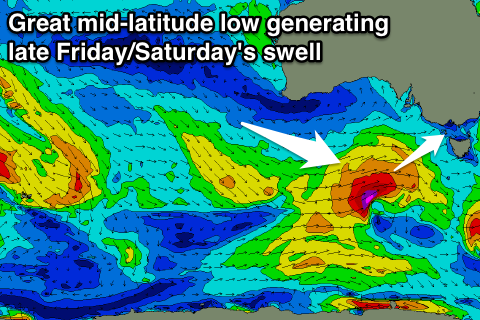
We'll next see some swell building through Friday, generated by a strong mid-latitude front pushing in from the west Wednesday evening and Thursday, projecting a great fetch of gale to severe-gale W/SW winds through our swell window.
The front will pass across Tassie and clip us Thursday evening/early Friday with the groundswell due to build through Friday, peaking later in the day and then easing Saturday.
 Friday morning will be small to tiny, but the swell should reach 3-4ft by dark on the Surf Coast and 6ft+ on the Mornington Peninsula but with onshore S/SW winds.
Similar sized sets are likely early Saturday with lingering SW winds (possibly W/NW around Torquay early).
Sunday will be a touch smaller but the Surf Coast is more likely to see a morning W/NW breeze with fun 3ft sets owing to a reinforcing mid-period swell.
Longer term small to moderate amounts of SW swell should persist into early next week, with a possible new S/SW groundswell pulse for Wednesday, but we'll have a closer look at this Wednesday.