Excellent waves tomorrow, great Wednesday then average to end the week

Victoria Forecast by Craig Brokensha (issued Monday 2nd October)
Best Days: Both coasts Sunday and Monday mornings, Tuesday morning Surf Coast, Wednesday morning Surf Coast, Thursday both coasts
Recap
Large surf out of the W/SW Saturday but with less than ideal conditions for all but protected breaks under gusty W/SW winds (W'ly for a period early on the Surf Coast).
Sunday was excellent with pumping 4-6ft waves on the Surf Coast as winds held offshore for the reefs until mid-afternoon, while the Mornington Peninsula was large and bumpy.
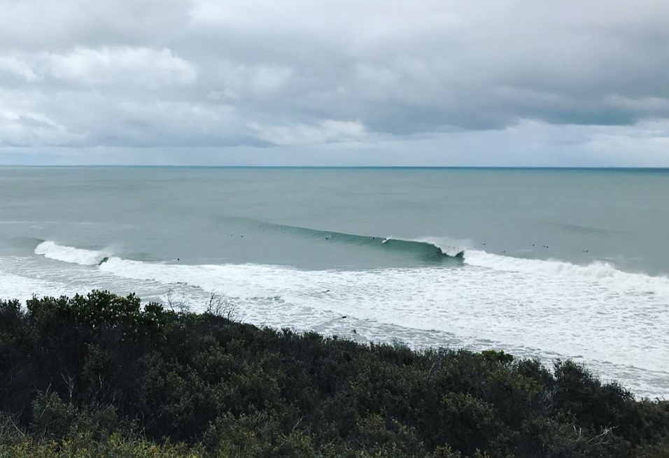
Today the swell is holding with some great new reinforcing SW energy filling in, with it due to strengthen a little further this afternoon. The Surf Coast is in the 3-5ft range with 6ft+ sets on the Mornington Peninsula and winds should remain favourable until mid-afternoon again.
A stronger increase in swell period should push the Surf Coast more towards the consistent 5ft range, with 6-8ft sets on the Mornington Peninsula.
This week and weekend (Oct 3 - 8)
Today's and more so this afternoon's reinforcing SW groundswell was generated over the weekend by an impressive broad and elongated fetch of W/NW-W gales moving from south-west of WA, under the country.
We should see the swell hang in tomorrow morning to a similar 5ft on the Surf Coast and 6-8ft on the Mornington Peninsula, easing just a touch into the afternoon but more so from Wednesday, down from 3-4ft and 6ft respectively.
Conditions will be great across most locations tomorrow morning with local offshores (light N/NW Surf Coast, and N/NE Mornington Peninsula) tending variable ahead of mid-afternoon sea breezes.
Wednesday looks best on the beaches with a light N/NE breeze, tending more E/SE into the afternoon.
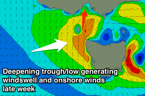 The swell will continue to ease into Thursday and winds look to take a swing to the S'th through the day as a deepening surface trough/low moves in from the west.
We're looking at early light N winds at this stage, giving into the change through the day, along with an increase in S/SW windswell later in the day and more so Friday with poor S'ly winds.
Into the weekend we'll see a mix of easing windswell and background W/SW groundswell as winds swing back to the NE Saturday and then N'th Sunday as a vigorous cold front approaches from the west.
This front may generate some decent swell into next week, but more on this Wednesday.
Comments
G'day Craigos,
Just enquiring about the consistency of the swell tommorow. Wondering if I'm gonna be getting 4b/m (baz's per min) or only the 2 b/m.
Cheers Barry. aka Basel destroyer696
I'd be more expecting the 4b/m side of things.
what size are we looking at for the w/e with winds looking good?
Bit early but likely easing 2-3ft Surf Coast magnets Saturday and 4ft on the MP. Smaller inconsistent 2ft Surf Coast Sunday with 3ft+ waves MP.