Fun period for the Surf Coast, largest over the weekend

Victoria Forecast by Craig Brokensha (issued Wednesday 27th September)
Best Days: Surf Coast Thursday morning, Friday, early Saturday, Sunday morning, Monday morning, both coasts Tuesday morning, east of Melbourne Wednesday
Recap
Some fun S/SW swell across the coast yesterday morning with clean conditions across the Surf Coast and average surf to the east. The swell eased into the afternoon and this morning it's back to the small to tiny range along with winds out of the NE.
This is favouring the exposed beaches east of Melbourne, but we should see some new S/SW swell this afternoon, pulsing to 2ft+ on the Surf Coast and 4ft on the Mornington Peninsula as winds tend variable east of Melbourne and light NW on the Surf Coast.
This week and weekend (Sep 28 – Oct 1)
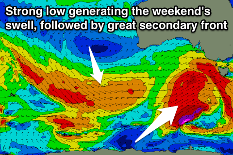
This afternoon's increase in S/SW groundswell was generated by a strong polar front to out south-southwest earlier this week.
Secondary activity on the back of an initial strong front should keep the Surf Coast up around 2ft to occasionally 3ft tomorrow at magnets with surf in the 4ft range on the Mornington Peninsula.
A morning W/NW wind will only favour the Surf Coast though, shifting W/SW late morning.
Our better SW swell for Friday is still on track with a broad but not overly strong polar front expected to push up ideally through our south-western swell window today and tomorrow.
A fun mid-period SW swell is expected, with it due to peak through the middle of the day Friday to 3ft across most spots on the Surf Coast, with the odd bigger one at magnets and 4-5ft+ on the Mornington Peninsula.
A NW tending fresh W/NW breeze will create clean conditions all day on the Surf Coast while locations east of Melbourne look to remain average.
This freshening W/NW'ly will be linked to a more vigorous polar frontal progression approaching from the west, linked to a strong node of the Long Wave Trough developing over us.
The structure of this system has changed a little with core wind speeds not expected to reach the storm-force range any more.
This will result in a bit less size than forecast on Monday, but coming back to the storm and a great broad fetch of gale to severe-gale W/SW tending SW winds being projected nicely through our swell window, moving across us Friday evening.
We'll see a large W/SW tending SW groundswell filling in through Saturday, peaking overnight and easing Sunday.
 The Surf Coast should see 3-5ft waves early, building towards 5-6ft into the afternoon and then easing back from 4-6ft Sunday morning. The Mornington Peninsula is likely to be around 6ft+ early Saturday, increasing to 8ft into the afternoon and easing from 8ft on the sets Sunday morning.
Gusty but easing W/SW winds will create less than ideal conditions on Saturday, though the Torquay region will likely see a period of W/NW winds.
Sunday should play out similar with a morning W/NW breeze around Torquay, tending W/SW through the day.
Next week onwards (Oct 2 onwards)
We'll see great waves continuing across the Surf Coast into early next week as a very drawn out secondary frontal system develops on the tail of the initial strong low.
A great fetch of W/NW gales will persist through our western swell window from Friday afternoon through Sunday while slowly moving east, angling away from our swell window.
What we should see is moderate amounts of W/SW groundswell, building Monday afternoon and peaking Tuesday morning.
The Surf Coast should hang around 3-4ft all day Monday with 3-5ft sets Tuesday, easing slowly from Wednesday. The Mornington Peninsula will see surf just over the 6ft range, more consistent to 6ft+ Tuesday.
A W/NW tending SW breeze will favour the Surf Coast on Monday while local offshores are expected on Tuesday ahead of sea breezes. Winds from the north-east quadrant are then due Wednesday as the surf starts to ease, but more on this Friday.