Protected reefs then exposed beaches

Victoria Forecast by Craig Brokensha (issued Monday 28th August)
Best Days: Surf Coast Tuesday and dawn Wednesday, more exposed breaks Thursday morning, Friday and Saturday
Recap
Pumping waves across the Surf Coast Saturday with an initial W/SW groundswell for the morning to 3-4ft being replaced by a stronger long-period SW groundswell from mid-late morning, providing large 5-6ft sets on the exposed reefs.
Conditions remained good all day, while Sunday saw a strong polar front push up and into us, bringing poor messy conditions but plenty of size.
This morning a mix of mid-period S/SW swell and SW groundswell were on the ease with winds improving a touch early around Torquay but conditions remained bumpy with 3-4ft sets. To the east conditions were poor and onshore.
This week and weekend (Aug 29 – Sep 3)
Conditions will clean right up across the Surf Coast tomorrow with a return to W/NW offshore winds as some reinforcing SW groundswell fills in. Swell magnets should pick up 3ft sets all day with 4-5ft waves on the Mornington Peninsula (but bumpy and average).
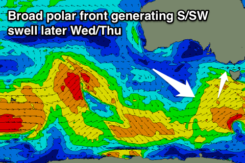
Another pulse of fun sized SW swell is due Wednesday, generated by a polar fetch of pre-frontal W/NW winds over the weekend. This will be followed up by a slightly bigger increase in S/SW swell through the afternoon and Thursday morning generated by a broad polar front projecting towards Tasmania this afternoon and tomorrow.
The swell will have a bit of south in it due to its positioning, with Wednesday morning coming in around 3ft on the Surf Coast and 4-5ft+ on the Mornington Peninsula, building to 3-4ft and 5-6ft respectively through the afternoon.
 Unfortunately the front will bring an onshore change Wednesday with early W'ly winds, due to swing S'ly mid-morning.
A ridge of high pressure will quickly move in behind the change, swinging winds back offshore for locations east of Melbourne Thursday out of the NE. There'll be plenty of size still on offer early, so the beaches may be too big.
Friday looks fun the swell continues to ease (likely from 3-4ft on the Mornington Peninsula) with fresh N/NE tending N winds.
Into the weekend there's no major swell due with background energy keeping the Mornington Peninsula topped up with small inconsistent 2-3ft waves (tiny on the Surf Coast).
Winds look to remain OK with a N'ly offshore Saturday and then NW to SW winds Sunday as a change moves through. Some new W/SW groundswell is due into Sunday afternoon, generated by a strong polar frontal progression projecting towards Western Australia mid-late week.
Beyond this we're looking at a more significant polar frontal progression firing up towards us early next week. More on this Wednesday.
Comments
Lorne shark attack.. Lorne shark attack: Shark leaves bite marks in board