Good westerly swells from Friday

Victoria Forecast by Craig Brokensha (issued Wednesday 12th July)
Best Days: Surf Coast Friday, Saturday, Sunday, Monday, east of Melbourne Sunday afternoon and Monday
Recap
Good clean Surf Coast waves yesterday to 3-4ft with the odd bigger set at magnets, and average large onshore waves to the east.
The swell eased a little into the afternoon but has dropped back further this morning to 2-3ft on the Surf Coast with clean conditions under a light offshore wind, and good clean 3-4ft on the Mornington Peninsula.
Winds should hold from the north all day as the swell continues to ease.
This week and weekend (Jul 13 - 16)
 Tomorrow is looking average as the swell continues to fade leaving tiny waves on the Surf Coast and small easing 2ft+ sets on the Mornington Peninsula. A strengthening N'ly wind will also likely blowout the swell through the day.
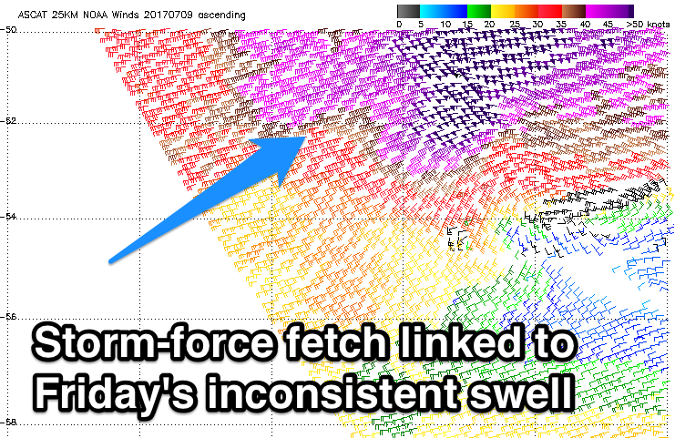
Into Friday our new inconsistent W/SW groundswell is still on track, with a vigorous polar front generating a fetch of severe-gale to storm-force W'ly winds in our far western swell window earlier this week.
This swell will be inconsistent but should come in at a good 3ft+ across swell magnets on the Surf Coast with 6ft sets on the Mornington Peninsula.
Moderate to fresh NW tending W/NW winds will favour the Surf Coast and create average conditions to the east.
The secondary slightly more west swell due into Saturday is now looking a little better for us compared to Monday.
While the storm generating this secondary swell is positioned a touch further north, it came in a touch stronger than forecast earlier this week, with severe-gale W/SW winds projected through our western swell window.
Another long-period and inconsistent W/SW groundswell will result, filling in overnight Friday and peaking Saturday morning. We'll also see the remnants of this storm push under the Bight while aiming strong W/SW winds through our swell window.
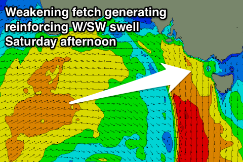 This will help keep wave heights up into the afternoon with more consistency.
The Surf Coast should come in at 3-4ft across most breaks with 5ft sets at swell magnets, and 6ft to occasionally 8ft waves on the Mornington Peninsula, easing slightly through the day.
Sunday looks smaller with easing sets 3ft+ and 5-6ft respectively.
Conditions will again be best on the Surf Coast Saturday with a W/NW tending W/SW breeze, while Sunday should become cleaner to the east with fresh N/NW tending N'ly winds. We'll confirm this on Friday.
Into Monday next week a new W/SW groundswell is due, generated by a pre-frontal fetch of W/NW gales passing under the country on the weekend. No major size is due, but a possible low forming west of us may swing winds straighter offshore from the N'th. We'll review this Friday.