Sub-par week compared to our recent run

Victoria Forecast by Craig Brokensha (issued Monday 3rd July)
Best Days: Surf Coast Tuesday morning, Thursday, Friday morning and Sunday
Recap
Freezing mornings over the weekend but great surf with easing waves from the 3ft+ range on the Surf Coast and 4-6ft on the Mornington Peninsula, back to a smaller 2ft and and 3-4ft+ respectively Sunday.
This morning we've hit a low point in between swells, with infrequent 3-4ft waves on the Mornington Peninsula and 1-1.5ft sets on the Surf Coast.
A new W/SW groundswell has hit Cape Sorell and should build to a very inconsistent 3ft on the Surf Coast this afternoon with 4-6ft sets on the Mornington Peninsula as persist from the N'th. A late check of the Surf Coast beaches could be worth it.
This week and weekend (Jul 4 - 9)
This afternoon's inconsistent W/SW groundswell isn't great and will ease off through tomorrow from 2-3ft at magnets on the Surf Coast and 4-5ft on the Mornington Peninsula along with NW winds. There may be a small window of N'ly winds at dawn on the Mornington Peninsula, but besides this conditions will be average.
Wednesday isn't looking too amazing with smaller surf left across the Surf Coast along with a NW tending W/NW breeze.
Later in the day we should see a new long-period and inconsistent SW groundswell starting to fill in.
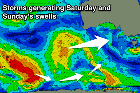
This swell was generated late last week and over the weekend by a very strong and powerful polar low. The low was strongest way on the edge of our swell window, west of Heard Island and weakened slightly while moving east along the polar shelf.
With this there'll be very long waits between sets, with a possible slight increase in size by dark Wednesday, with a peak due Thursday morning to an infrequent 3ft+ at Surf Coast swell magnets (Bells and Winki are likely to see stray 4ft sets), and 5-6ft on the Mornington Peninsula.
The swell will ease into the afternoon, further down into Friday.
Winds on Thursday will favour the Surf Coast, with a NW tending light N/NW breeze.
Friday morning is currently looking best for the beaches east of Melbourne with a morning N'ly ahead of a shift back to the NW into the afternoon.
 The weekend is looking a bit hit and miss.
We'll see another poorly aligned and weak polar frontal progression generating a small inconsistent W/SW swell for Saturday, but there's nothing over 2ft expected at swell magnets on the Surf Coast with 3-4ft+ waves to the east.
Winds are looking a little funky as well but likely N/NW all day.
Into Sunday another very inconsistent SW groundswell is due, produced by a relatively weak polar frontal system in the Heard Island region, generating pre-frontal W/NW gales.
Only an inconsistent 2-3ft wave is due on the Surf Coast with 4-5ft sets to the east with fresher N/NW winds. Longer term the storm track remains split with weak mid-latitude and polar frontal systems failing to generate any significant swell for us, but more on this Wednesday.