Clean weekend with fading swell, westerly energy next week

Victoria Forecast by Craig Brokensha (issued Friday 19th May)
Best Days: Both coasts Saturday (Surf Coast early for most size), east of Melbourne later Monday and early Tuesday, Surf Coast Wednesday and Thursday
Recap
Tiny average surf yesterday across the Torquay region and small but cleaner to the east, while today we're seeing an average mix of SE windswell and building S/SW groundswell.
Conditions are best east of Melbourne and OK at selected beaches on the Surf Coast. The Cape Sorell buoy is looking strong and the Tasmanian South Arm came in solid as expected, so we should see consistent 3ft sets hitting the Surf Coast by late morning and 4-5ft on the Mornington Peninsula as winds persist from the E/NE.

This weekend and next week (May 20 – 26)
We'll see conditions really clean up over the weekend but the surf will become small and bottom out Sunday.
Tomorrow a mix of easing S/SW groundswell and smaller SE windswell should drop from 2ft on the Surf Coast with 3ft to possibly 4ft sets on the Mornington Peninsula with N'ly winds.
Sunday will be even smaller, tiny on the Surf Coast and in the 2ft+ range on the Mornington Peninsula as winds persist from the N'th.
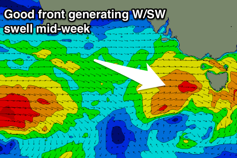
As talked about last update another mid-latitude low moving in from the west over the weekend and early next week will generate some acute W'ly swell from Tuesday next week.
This system is now looking a little better for swell generation on the Surf Coast into Wednesday/Thursday. But the initial stages of the low, south of WA is expected to generate a pulse of new acute W/SW groundswell Monday afternoon on the Mornington Peninsula.
A burst of strong to gale-force W/SW winds should kick to 3-4ft late in the day as winds hold from the N'th. The Surf Coast will remain tiny.
Moving into early next week, and a fetch of strong W/SW winds will be projected through the Bight Sunday evening and Monday, generating a new W/SW swell for Tuesday, building to 2ft on the Surf Coast into the afternoon and 4-5ft on the Mornington Peninsula.
 Conditions are looking favourable for both coasts with an early N'ly wind, due to swing NW into the afternoon as the swell builds.
Of greater importance is a better and stronger fetch of near gale-force W/SW winds projecting through our western swell window and across us Tuesday evening and Wednesday.
This should produce some better W/SW swell for Wednesday and Thursday morning. If everything goes to plan we should see better sets to 3ft+ developing into Wednesday afternoon on the Surf Coast with 5-6ft waves on the Mornington Peninsula, easing back Thursday.
Winds will hold from the W/NW-NW both Wednesday and Thursday, keeping conditions clean on the Surf Coast and average to the east.
Into the end of the week we may see a secondary stronger front pushing into us, but more on this Monday. Have a great weekend!
Comments
Hi Craig
The WAMS have the forerunners of Monday's west swell hitting Cape Otway in the Morning at 4ft +Do you expect there to be a decent swell size difference as predicted in the WAMS?
Will MP/ P island drop much in size from Sunday night into Monday AM?
Cheers
Yeah I don't expect Monday morning to offer much size at all.
Maybe inconsistent stray 2ft sets on the MP.
Day mackdog just head to the west coast more reliable.
Classic junkie
The crew from Surfing Vic scouting 13th Beach for a bank this morning. Looks fun!