Small windows of opportunity

Victoria Forecast by Craig Brokensha (issued Wednesday 15th March)
Best Days: Early tomorrow both coasts, east of Melbourne Saturday morning and Sunday
Recap
Tiny surf yesterday morning on the Surf Coast with small clean conditions on the Mornington Peninsula. Weak sea breezes developed through the day, but a strong new pulse of SW groundswell also kicked with size as winds tended more variable, hitting 3ft on the Surf Coast and 5-6ft on the Mornington Peninsula.
This swell has held in this morning with offshore winds across most breaks, but we'll see a drop in size through the day with afternoon N/NE winds, more E/NE late.
This week and weekend (Mar 16 – 19)
Our current SW groundswell will ease off further tomorrow from a small 2ft on the Surf Coast and 3-4ft on the Mornington Peninsula and early conditions are looking good. A light offshore wind is due at dawn, but don't dawdle as a SW change is due mid-morning.
Come Friday our mix of long-period W'ly groundswell and closer-range W/SW swell will be spoilt by fresh SE winds.
The closer-range energy should produce a weak 2ft+ wave at exposed breaks on the Surf Coast and 3-4ft+ waves on the Mornington Peninsula but with no quality options.
The swell will ease off through Saturday, slowed by a reinforcing W/SW swell from a weak mid-latitude front.
The Surf Coast should ease from 2ft with 3-4ft sets on the Mornington Peninsula with better E/NE tending NE winds across the beaches.
Sunday should be clean across most locations with local offshore winds, but the swell will be small to tiny and very inconsistent (outlined below)
Next week onwards (Mar 20 onwards)
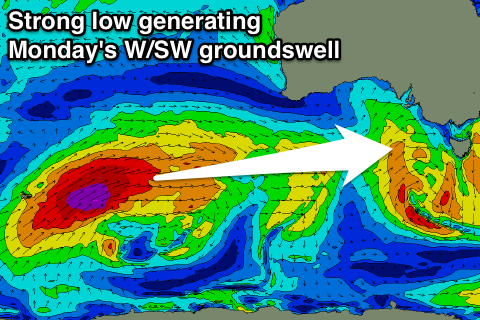 A better long-range W/SW groundswell is due across the state next Monday and Tuesday, with the storm linked to this swell already forming south-east of South Africa on Monday.
This low is in our far far swell window, but is now pushing east along the polar shelf while generating a fetch of severe-gale W/SW winds. The low will re-strengthen while tracking up towards WA, on the edge of our western swell window, further out of it as it weakens.
Two inconsistent W/SW groundswells are due off this low, the first and with no size is due Sunday with very infrequent 2-3ft waves on the Mornington Peninsula, but the best pulse for Monday should build to 3-4ft into the afternoon on the Surf Coast and 5-6ft+ on the Mornington Peninsula.
Unfortunately an onshore S'ly change is due early Monday morning, lingering from the S/SE Tuesday creating average conditions.
Longer term a good S/SW groundswell is on the cards for Thursday but a possible low deepening off the East Coast could again bring poor winds. More on this Friday.