No surfing days until next week

Victoria Forecast by Craig Brokensha (issued Wednesday 8th February)
Best Days: Wednesday morning east of Melbourne
Recap
Terrible conditions yesterday on the Surf Coast with strengthening E/SE winds and a building SE windswell, while the Mornington Peninsula saw a bumpy and peaky mix of swells.
This morning conditions were much better on the beaches across the state with E/NE-NE winds and an easing SE windswell from 2ft on the Surf Coast, mixed in with a SW swell to 2ft on the Mornington Peninsula.
This week and weekend (Feb 9 - 12)
Looking into tomorrow, there isn't expected to be any real SE windswell left at all, same with background SW energy. So we're looking at tiny waves on both coasts under an early fresh N'ly wind, giving into a change around midday/early afternoon.
Unfortunately the swell for Friday has been wiped, with the late forming fetch in our swell window now due to be a mixed mess of weak winds.
Therefore tiny waves will continue Friday and winds look dicey with a lingering S'ly breeze (possibly variable at stages) but with no swell it's not worth worrying about.
Into the start of the weekend, swell sources will remain scarce, with tiny surf due to the west of Melbourne, while a small background W/SW swell may see 2ft sets on the Mornington Peninsula.
 Winds aren't looking too flash though with an early light SW'ly expected to freshen through the day.
This SW'ly will be linked to a good polar frontal progression firing up through our swell window late week and through the weekend.
An initial weak polar front is expected to produce a small W/SW swell for Sunday, building through the day, followed by a better aligned and strengthening front projecting up and into us.
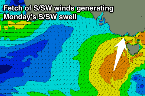
This front will project a fetch of strong to near gale-force S/SW winds towards us Saturday and Sunday, producing a moderate sized S/SW swell for Monday.
Sunday's swell is expected to build to 2-3ft at exposed breaks on the Surf Coast into the afternoon and 4-5ft on the Mornington Peninsula, with the S/SW swell building to 3-5ft and 6ft+ respectively Monday afternoon.
The only issue are the local winds, with a gusty SW'ly moving in Sunday, persisting from the S/SW Monday as the better swell fills in. Tuesday will remain onshore as the swell starts to ease.
Longer term we should see the Mornington Peninsula clean up Wednesday as the swell continues to drop, with some better swell potential later next week. More on this Friday.