Poor week ahead, best Wednesday morning

Victoria Forecast by Craig Brokensha (issued Monday 5th February)
Best Days: Beaches on the Surf Coast Wednesday morning, similar east of Melbourne
Recap
A great weekend of surf with a good reinforcing W/SW groundswell Saturday (too big for the beaches to the east) but clean and 3ft on the Surf Coast with 4ft sets at 13th Beach.
Sunday provided better options to the east with solid easing 4-5ft sets and 2-3ft waves on the Surf Coast. Conditions were clean until sea breezes kicked in, followed by a stronger onshore change overnight.
This change along with small leftover amounts of swell has resulted in poor conditions today.
This week (Feb 7 - 10)
As touched on last update this week isn't looking too flash at all. After our good run of waves last week we're looking at a typical summer week of surf with small to tiny swells and poor winds.
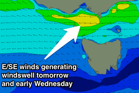 Through tomorrow strengthening E/SE winds will create terrible conditions but also kick up a junky and stormy SE windswell for the Surf Coast, reaching 3-4ft by dark at exposed breaks to the swell.
These winds will be the result of a surface trough squeezing a strong high moving east across us, and as this high continues east Wednesday we'll see winds swing more E/NE across the coast creating clean conditions on the Mornington Peninsula, OK at selected spots on the Surf Coast.
The SE windswell will ease steadily from 3ft or so early on the Surf Coast, tiny later. The Mornington Peninsula should be around 2ft+ or so, also easing.
Come Thursday there's expected to be no swell left across the coast and an early N/NW offshore will give into a change mid-late morning as a surface trough moves across us.
This trough will be linked to a stronger low forming to our south-west, but the models are diverging on the strength of this system this morning.
Some form of new SW swell is due, but it looks to be on the smaller size and lingering S/SE winds in the wake of Thursday's change will create average conditions.
This weekend onwards (Feb 11 onwards)
Friday's swell will ease off as quickly as it arrived but winds are a little unsure at this stage.
Following this some new W/SW groundswell is due through Sunday and Monday from a broad and good polar frontal progression. The only problem looks to be the local winds again, with onshore S/SE breezes on the cards as a new ridge if high pressure moves in with the swell, but more on this Wednesday.