Fun waves over the coming days

Victoria Forecast by Craig Brokensha (issued Wednesday 1st February)
Best Days: Thursday and Friday mornings Surf Coast, Saturday and Sunday mornings both coasts
Recap
Clean conditions early around Torquay with small 2ft waves ahead of a new increase in W/SW groundswell through the day, reaching an easy 3ft but with S/SW winds. The Mornington Peninsula was bumpy and onshore.
Today was much cleaner across both coasts with light offshores on the Surf Coast and variable winds to the east along with good amounts of swell between 3ft and occasionally 4ft to the west and 5-6ft to the east.
This week and weekend (Feb 2 - 5)
Today's swell will ease off slowly from this afternoon, more so into tomorrow morning leaving 2-3ft waves on the Surf Coast and 4-5ft waves on the Mornington Peninsula.
A morning W/NW breeze will create clean conditions on the Surf Coast, tending W/SW late morning.
Our new pulse of W/SW swell for Friday is still on the cards, but the secondary pulse for Saturday morning now looks to be the strongest of the two.
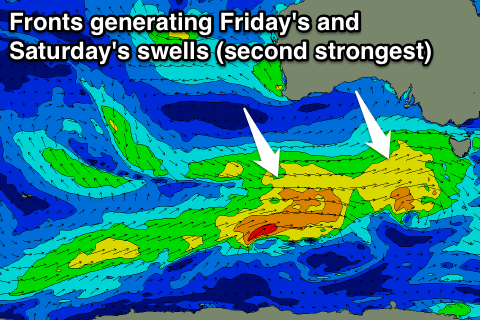 These swells will be generated by a couple of broad mid-latitude fronts moving in south of the Bight over the coming days. The first system will be weakest, with the secondary system slightly stronger and also moving over an active sea state.
Friday's pulse should see 3ft waves across the Surf Coast (a little bigger at 13th Beach), and 4-5ft+ on the Mornington Peninsula.
A morning NW wind will again favour the Surf Coast though, tending W/SW through the day.
The secondary pulse for Saturday looks to come in around 3ft again but with more power, easing off slowly Sunday from 2-3ft. The Mornington Peninsula should offer 5-6ft sets Saturday, easing from 4-5ft Sunday.
Conditions are looking good across both coasts Saturday with local offshore breezes ahead of afternoon sea breezes, similar Sunday but with a slight west tendency in the wind.
Longer term an onshore change Sunday afternoon will leave SE winds into Monday along with small easing levels of swell.
We'll then see a strong high stalling to our west directing E/SE winds into the coast kicking up poor levels of SE windswell, mixed in with small amounts of mid-period SW swell. More on this Friday.