Small W/SW swells from Wednesday with light winds each morning

Victoria Forecast by Craig Brokensha (issued Monday 23rd January)
Sign up to Swellnet’s newsletter and receive the Victorian Forecaster Notes and latest news sent directly to your inbox. Upon signup you'll also enter the draw to win a surf trip to P-Pass for you and a mate (this is the last week to enter). It doesn’t get much easier so click HERE to sign up now.
Best Days: Both coasts Wednesday morning, Surf Coast Thursday morning, both coasts Friday morning, Surf Coast Saturday morning, both coasts Monday morning
Recap
Small average 1-2ft waves on the Surf Coast Saturday morning with sloppy 2-3ft surf to the east.
Yesterday was better with a slightly stronger mix of swells and a lighter offshore wind for the Mornington Peninsula and Phillip Island while the Surf Coast was also cleaner but tiny.
Today small marginal surf has continued with no real swell on the Surf Coast and clean 2-3ft sets on the Mornington Peninsula.
This week (Jan 21 - 22)
Tomorrow morning looks to remain small on both coasts, but an approaching front should produce a small increase in W/SW swell through the afternoon and more so Wednesday morning.
This front will also bring average winds (with the lack of swell on the Surf Coast) with an early W'ly due to give into a gusty SW change mid-morning.
The Surf Coast should reach a choppy 2ft into the afternoon with 4ft waves on the Mornington Peninsula but with no quality.
 The swell is expected to peak Wednesday, but only to 2ft+ max at magnets on the Surf Coast and 4ft+ on the Mornington Peninsula.
Conditions are looking OK with a variable wind from the south likely, but keep an eye on the local winds observations, ahead of afternoon sea breezes.
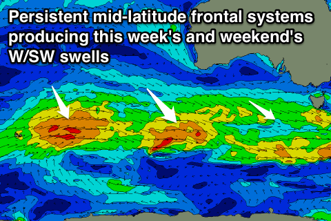
Secondary weak fronts moving in one after the other, but generating less than favourable W/NW fetches will continue to produce small pulses of W/SW swell through the rest of the week.
3ft sets are unlikely on the Surf Coast, as are 5ft'ers on the Mornington Peninsula with an early W/NW'ly Thursday morning around Torquay (W/SW-SW everywhere else) and more variable winds again into Friday morning.
This weekend onwards (Jan 28 onwards)
Another reinforcing pulse of W/SW groundswell is expected Saturday from continued mid-latitude frontal activity through our swell window, coming in around 2ft+ on the Surf Coast and the 4ft range on the Mornington Peninsula.
A stronger and bigger swell is due Sunday though as a more significant fetch of strong and persistent W/SW winds move in under the country late week.
This should fill in Sunday and provide surf more to 3ft on the Surf Coast and 4-5ft+ on the Mornington Peninsula.
Winds on Saturday look offshore for the Surf Coast ahead of a change, with lingering SE-E/SE winds on Sunday. This may tend E/NE on the Mornington Peninsula, but we'll review this Wednesday.
Into Monday better offshore winds are due across both coasts as the swell slowly eases, with some new small to moderate W/SW swell on the cards for next week.