Fun waves on the beaches with easing surf

Victoria Forecast by Craig Brokensha (issued Monday 26th December)
Sign up to Swellnet’s newsletter and receive the Victorian Forecaster Notes and latest news sent directly to your inbox. Upon signup you'll also enter the draw to win a surf trip to P-Pass for you and a mate. It doesn’t get much easier so click HERE to sign up now.
Best Days: Both coasts Sunday and Monday mornings, Tuesday morning Surf Coast, Wednesday morning Surf Coast, Thursday both coasts
Recap
An average Saturday with tiny waves on the Surf Coast and a few small waves east of Melbourne but not the cleanest conditions.
Sunday was a little better with a new inconsistent W/SW groundswell showing at a better 2-3ft on the Mornington Peninsula with offshore winds.
Today started slow and clean as expected but a strong new W/SW groundswell is currently on the build along with a gusty and relieving S/SW change. The change is expected to ease off through the late morning, possibly tending variable as the swell builds to an inconsistent but strong 3ft on the Surf Coast and 6ft on the Mornington Peninsula. Therefore an afternoon surf is more than on the cards.
This week (Dec 27 - 30)
This afternoon's increase in W/SW groundswell should ease off slowly through tomorrow from 2-3ft on the Surf Coast and 4-5ft on the Mornington Peninsula.
Easterly winds will favour the Mornington Peninsula and Phillip Island tending E/NE-NE through the morning and possibly persisting until mid-afternoon.
If you're keen for a surf west of Melbourne head to the beaches mid-late morning.
 The surf is due to become small to tiny on the Surf Coast Wednesday but the Mornington Peninsula will be fun with 3ft+ or so of swell, easing with N/NE winds.
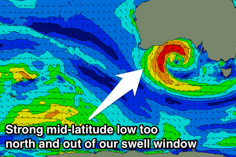
Unfortunately for the rest of the week there's nothing significant on the cards swell wise, as a mid-latitude forms off WA and stalls high in the Bight, out of our swell window for the rest of the week.
This will block our main swell window, leaving us to rely on long-range energy.
Thursday is due to be tiny to small across both coasts with a variable tending N'ly wind ahead of sea breezes, while Friday a very inconsistent and small long-range W'ly swell is due from the Indian Ocean.
No size is expected on the Surf Coast, but the Mornington Peninsula should see 2-3ft sets along with a morning N/NE breeze ahead of a W'ly change linked to the mid-latitude low moving in from the west.
This weekend onwards (Dec 31 onwards)
By the time the mid-latitude low moves into our swell window Friday afternoon/evening it will be very very weak and no major swell is due off it into Saturday.
Only small fading levels of inconsistent W/SW groundswell are due, tiny on the Surf Coast and 2-3ft on the Mornington Peninsula with a morning NW breeze.
Into Sunday a very very inconsistent long-range W/SW groundswell is due to build, with it being generated currently in the southern Indian Ocean south-east of Madagascar. A slow moving and strong polar low will track towards us, breaking down in our far swell window.
Without any other significant swell sources it's worth noting, and should build through Sunday to a small 2ft+ on the Surf Coast and 3-5ft on the Mornington Peninsula through the afternoon, but with W'ly tending SW winds.
Some more consistent W/SW swell may be seen Monday/Tuesday but more on this Wednesday.
Comments
Winds have gone variable as expected with a kick in swell. Some fun options on the beaches.