Fun couple of days before dicey winds and smaller surf kick in

Victoria Forecast by Craig Brokensha (issued Monday 7th November)
Best Days: Surf Coast Tuesday morning, both coasts Wednesday morning, east of Melbourne Friday morning
Recap
The winds and conditions were not as strong or as bad as expected across the Surf Coast on Saturday with a moderate W'ly wind and large building swell to an easy 6ft+ across the reefs. Protected spots were fun and more manageable for most.
Sunday saw great conditions as the swell eased back from 4-6ft with favourable winds for the Surf Coast reefs most of the day.
Today much smaller surf is breaking across the region with 2-3ft sets on the Surf Coast, and 3-5ft surf on the Mornington Peninsula with light local offshore winds. Winds should tend more NW through the day ahead of a late shallow onshore change.
This week (Nov 8 - 11)
We've got another good couple of good days for the Surf Coast coming up, with a moderate sized W/SW tending SW groundswell due to build tomorrow, easing back slowly Wednesday and into the rest of the week.
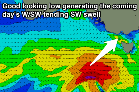 This is being generated by a strong mid-latitude frontal system moving in under the Bight, generating a fetch of W/SW gales. This front will spawn a little low this morning, with stronger severe-gale W/SW winds due to be generated in our south-west swell window before system passes under Tassie early tomorrow morning.
A good building W/SW groundswell is expected through tomorrow, reaching 3-4ft on the Surf Coast through the mid-late morning and 5-6ft on the Mornington Peninsula.
A peak is expected overnight, with the swell easing from a slightly more SW direction Wednesday morning. The Surf Coast is likely to still be in the 3ft+ range early, with 4-5ft+ waves on the Mornington Peninsula, smaller and more around 2ft and 3-4ft respectively Thursday morning.
Winds tomorrow will be best for the Surf Coast with a light to moderate W/NW breeze, tending SW around midday, while Wednesday is a little tricky but light variable winds are likely across both coasts, creating fun conditions.
A light lingering S/SE'ly on Thursday won't be ideal, continuing into Friday but likely E/NE early on the Mornington Peninsula, strong from the E/SE into the afternoon.
This weekend onwards (Nov 12 onwards)
The weekend isn't looking too flash at this stage with an inland surface trough due to deepen and then push east.
This will result in a junky SE windswell and SE tending SW winds on Saturday and then a strengthening W/SW'ly Sunday and building W/SW windswell.
Better conditions are due into next week, but more on this Wednesday.
Comments
General question for Craig,
It seems these last couple of months have had a pattern of successive strong fronts, excellent offshore winds, good amounts of rain, large swells and small pauses of fine (increasingly warm) weather between them. From memory, it's been very regular. And what I would consider "a proper winter" pattern. Is there any reason for this? Have we had successive LWTs to the SW of Vic?
Cheers
It's a combo of a negative AAO/SAM index (below) and also some help with nodes of the LWT nudging the country, but no major outbreaks that bring larger swells.
The negative SAM index sees the polar westerlies shifting more north towards Australia, while it's opposite when positive.
Interesting to compare the long term trend of the SAM/AAO (bottom graph) and that's towards a mainly positive phase which pushes the westerlies further away from us and closer to the poles.
The past few months have been against this, hence it seeming to be different to 'normal'.
Thx Craig, is there anything that could be causing this divergence from the upward trend? I also note central Eurasia is getting hammered by snow, and polar vortex centre more in that location - winds then carry cold air over NAmerica, hello bumper cold seasons and snow!
https://weather.com/news/weather/news/snow-siberia-russia-united-states-...
Good to see the swell has filled in.
Had to look it Craig
The Southern Annular Mode (SAM), also known as the Antarctic Oscillation (AAO), describes the north–south movement of the westerly wind belt that circles Antarctica, dominating the middle to higher latitudes of the southern hemisphere.
When will it piddle off and we can have some warm weather?
Mate, I'll kill for some cold weather and waves up here in Northern NSW. Be careful what you wish for!
Here's the forecast (from 2nd chart down)..
Looks to be not for a while.. strong negative into the middle of November.
F:$k this westerly shit! We get one day of good winds/waves then weeks of westerly
not sure how much more piddly, cold, crumbly westernport I can take
Maybe it will could end up with a winter of NE's. Ofcourse not
After the pole shift completes, Nick. Melbourne will be near the equator, so Indo style temps and wind belt to boot.
(lol)
In regards to SAM/AAO, does that mean when positive it pushes up the low pressure systems? Cause there higher as the swing past vic they bring more west?
No when positive they are further away. It's inverse relationship in that way. Negative means closer to Australia.
Thanks Craig for the detailed replies, awesome. It's welcome tbh, bring those life giving rains closer to southern Oz. I like the cooler, stormy weather.