Fun beachy waves tomorrow, Surf Coast reefs from the weekend

Victoria Forecast by Craig Brokensha (issued Wednesday 7th September)
Best Days: Beaches tomorrow, east of Melbourne Friday morning ahead of the change, Surf Coast Sunday and early Monday
Recap
Excellent waves across the Surf Coast again yesterday with clean 4ft surf for most of the day, before an onshore change moved through mid-afternoon. The Mornington Peninsula was also clean but too large for the beaches.
Today the swell was back to the 3ft+ range on the Surf Coast and 5ft on the Mornington Peninsula with excellent conditions under light variable tending light offshore winds. A slight drop in size is due into the afternoon as winds tend more NE.
This week and weekend (Sep 8 - 11)
A steady drop in surf is due across the state from this evening and fresh N/NE winds will favour the beaches across the state.
Easing 2ft+ sets are due across the Surf Coast (biggest at 13th Beach) with easing 3-4ft+ waves on the Mornington Peninsula. Winds may tend more N/NW on the Surf Coast through the day, but with no major size for the reefs, it's a mute point.
Friday is looking average with the swell bottoming out, and early light winds will give into a W/SW change. The timing of this change is still a bit undecided by the models, with it possibly not occurring until later in the morning. If you're desperate try the Mornington Peninsula during the morning for a wave.
Later in the day Friday we may see a new W/SW groundswell that's due Saturday fill in, along with a secondary slightly more consistent pulse.
These swells have and are still being generated in our far swell windows by a vigorous polar frontal progression in the south-east Indian Ocean.
The timing has been delayed a little as well as a slight drop in the size expected, with the Surf Coast due to build to 2-3ft through the day, with 4-5ft+ sets on the Mornington Peninsula.
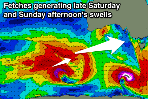 Later in the day and more so Sunday morning a better W/SW groundswell should be seen, generated by a pre-frontal fetch of severe-gale W/NW winds at the head of a strong polar low forming south-west of WA.
This should see more consistent 3ft sets across the Surf Coast on dark Saturday, holding Sunday morning to 3ft+ with 6ft sets on the Mornington Peninsula.
Into Sunday afternoon though the groundswell from the polar low proper will fill in, with a fetch of severe-gale to storm-force W/SW winds being generated through our swell window.
The Surf Coast should see solid 4ft sets into Sunday afternoon (if not bigger at magnets) with 6ft to occasional 8ft sets on the Mornington Peninsula.
Conditions will be best on the Surf Coast over the weekend with a morning W/NW breeze Saturday, tending SW through the day and NW tending variable winds Sunday.
Next week onwards (Sep 12 onwards)
Sunday afternoon's kick in swell should ease back a touch into Monday morning, but a reinforcing SW groundswell is due into the afternoon, generated by a secondary polar front firing up closer to us (south-west of Tassie) through the weekend.
The surf should kick to 3-5ft on the Surf Coast into the mid-late afternoon, with 6-8ft sets on the Mornington Peninsula Monday, but early light winds will give into a S/SE change, creating poor conditions.
Tuesday doesn't look much better with easing surf with strengthening E/SE winds.
Longer term there's plenty more strong SW groundswell for next week and winds should improve late week, but more on this Friday.