Smaller swells with light winds the coming mornings

Victoria Forecast by Craig Brokensha (issued Monday 22nd August)
Best Days: Both coasts each morning Tuesday and Wednesday, Surf Coast Friday, east of Melbourne Saturday and Sunday
Recap
Saturday.. On Friday I was slightly hesitant on how west in nature the swell was expected to be, but satellite observations quelled those doubts, confirming a great and slow moving fetch of storm-force winds in Victoria's west-southwest swell window.
Come Saturday morning the buoy reading were great off Tasmania, but inside Bass Strait, very underwhelming. Whether the swell was steered away somewhat or was just too west for Victoria is not quite known, but if I had the similar system fire up this week I probably wouldn't change much from what I forecast Friday. The Surf Coast was clean but struggling to top 3ft on the sets, while the Mornington Peninsula didn't see any overly large surf either.
Into Sunday we saw some better aligned SW swell filling in from the low as it drifted more favourably into out swell window, with good fun but slightly lumpy 3-4ft waves across the Surf Coast with 6ft sets to the east.
Fun amounts of S/SW swell have continued into today from the remnants of the slow moving and weakening low, continuing at 2-3ft on the Surf Coast (bigger sets at 13th Beach) and 3-5ft on the Mornington Peninsula with improving conditions as early W/NW winds tended light N'ly.
This week (Aug 23 - 26)
The current run of swell from the weakening and stalling low south of Tassie will continue from the S/SW tomorrow morning, mixed in with a distant and inconsistent W/SW groundswell.
Wave heights look to come in around 2ft+ across the Surf Coast and 3-4ft+ on the Mornington Peninsula. Conditions will be a little funky with a weak surface trough moving through the region, with early variable winds expected across both coasts, increasing from the S/SW through the day.
Wednesday should see similar conditions with early variable winds, increasing from the S/SW through the day. A slightly bigger but inconsistent W/SW groundswell is due, generated in the south-east Indian Ocean, keeping 2ft to possibly 3ft sets hitting magnets like 13th Beach on the Surf Coast and 3-5ft waves on the Mornington Peninsula.
Our dynamic and deepening inland low that was forecast last week isn't expected to play out as forecast by the models, with a cold outbreak across WA not combining with an infeed of moisture from the north.
Instead these systems will work independent of each other, with the cold outbreak drawing in cold onshore S/SW winds on Thursday. The Surf Coast is likely to see early W/NW breezes, but there won't be much size on offer.
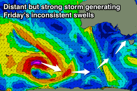 Into Friday a very inconsistent long-range W/SW-SW groundswell is due across the state, generated by a sustained and strong polar frontal progression moving through the southern Indian Ocean. This progression developed south of South Africa last week, and has been moving towards us, with it now being east of Heard Island, generating a weakening fetch of severe-gale W/SW tending W/NW winds.
The initial stages of this progression was in our western swell window, with the final stages more in out south-western swell window.
The Surf Coast should see inconsistent but fun 3ft sets through the day, with 4-6ft sets on the Mornington Peninsula. Winds should tend W/NW across the Surf Coast, but we'll have another look at this Wednesday.
Into the weekend, easing surf with northerly winds are expected favouring locations east of Melbourne.
Comments
Thanks Craig,
The swell direction listed on the surf forecast, let's use torquay as an example, where is it referenced to? Pt Nepean? Cape Sorrell?
If memory serves, the direction on Saturday for Torquay was forecast at 245 degrees, where could I go and cross reference this with what actually occurred?
Cheers
Direction is for about 5km directly offshore from Torquay to the south-east.
Only tool we have is Point Nepean but that's also experienced refraction from spreading into Bass Strait. Last readings I can access show direction 215deg.
Would be great to have Cape Sorell showing direction as that would give a more true reading.
Cheers, although as I was expecting the direction to be linked to a verifiable point it creates more questions:
Presumably, this point 5km from Torquay is calculated by the models based on the initial swell direction (determined from wind / synoptic charts) and then adjusted for refraction into Bass Straight?
Assuming yes, what factors are used in the the refraction calculation: Period, local bathymetry, tide, other?
An earlier article on Swellnet talked about the tidal influences on direction in Bass Strait - is this factored into your models' predictions or is it left to the realms of 'local observations and knowledge'?
Thanks in advance
Refraction is calculated by the models and dependent on how coarse the model grid is as well as the bathymetry file going into it.
No, none of the tidal stuff is factored in, just local knowledge etc.
Thanks!
So many variables, so interesting.
Nice glassy waves across the MP..
Gary would love if you set up a hind-casting website called 'SwellNot'
Deceptively fun at Lorne this morning!
https://www.swellnet.com/surfcams/lorne
That wave is not even knee height :))), but there is always someone out at the point.
surfed/matted the point sunday arvo .. few 3ft sets with no one out, tide bottoming out .. trippy. he can have it haha