Fun period for the Surf Coast

Victoria Forecast by Craig Brokensha (issued Wednesday 10th August)
Best Days: Surf Coast every day (small Saturday), east of Melbourne Friday and Monday/Tuesday
Recap
Tiny surf continued across the Surf Coast yesterday, while the Mornington Peninsula saw small clean waves for desperate surfers.
This morning some new signs of W/SW swell were showing across both coasts with 1ft sets to the west of Melbourne and 3ft sets on the Mornington Peninsula under gusty N-NW winds.
We should see a new long-period increase in inconsistent W/SW groundswell this afternoon across both coasts, reaching at least 3ft on the Surf Coast by dark and 5-6ft on the Mornington Peninsula as winds hold from the NW.
This week and weekend (Aug 11 - 14)
Our better and slightly bigger pulse of mid-period W/SW swell due tomorrow is still on the cards with various fetches of W/SW gales projecting towards us under the country through the Bight yesterday and further this morning.
Two pulses of W/SW swell are due tomorrow, one for early in the day and the other for later in the day, both coming in around 3-4ft on the Surf Coast and 6ft+ on the Mornington Peninsula. The late afternoon kick may produce the odd bigger bomb at swell magnets across both coasts.
Conditions will be best on the Surf Coast with a NW offshore ahead of a shallow W'ly change into the afternoon, while Friday will become cleaner at selected locations to the east with fresh N/NW breezes. Easing 3ft+ sets are due on the Surf Coast, with 5-6ft waves on the Mornington Peninsula.
Heading into the weekend, we were looking at a small and intense mid-latitude low pushing into us Saturday.
This low will develop south-west of WA this afternoon but weaken while moving south of the Bight, resulting in no real increase in short-range W/SW swell Saturday. The Surf Coast will be small with 2ft+ sets, larger to 3-5ft on the Mornington Peninsula.
The groundswell from the low for Sunday is still expected, but the size has also been upgraded with a secondary stronger mid-latitude frontal progression pushing in an over the top of the small low.
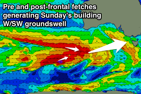 An additional fetch of pre-frontal severe-gale W/NW winds will be generated over an already active sea state, followed immediately by a more polar W/SW fetch.
This will result in a moderate to large W/SW groundswell being generated for Sunday, building through the day, peaking overnight and easing Monday.
The Surf Coast should build from 3-4ft through the morning to a larger 4-6ft later in the day, easing back from 4-5ft+ Monday morning. Larger surf is due on the Mornington Peninsula, building to 8ft on the sets through the day, and easing from 6-8ft Monday morning.
Now, conditions Saturday should remain clean all day on the Surf Coast with a W/NW offshore, with Sunday seeing similar conditions.
Next week onwards (Aug 15 onwards)
Monday looks excellent as the groundswell eases under NW tending variable winds, a touch smaller into Tuesday with N/NW breezes.
Some reinforcing but smaller W/SW pulses are on the cards for next week generated by unfavourably tracking mid-latitude fronts and lows through our swell window, but more on this Friday.
Comments
I'd give it a crack.
Keen as mustard
Swells like this sunday have been rare lately , this should be a bit better than the recent conditions . Sunday funday
Yeah it's not epic by any means, but a good sized long-period swell event.
This is looking a bit better..