Average end to the week, fun Sunday and cleaner next week

Victoria Forecast by Craig Brokensha (issued Wednesday 20th April)
Best Days: Desperate surfers exposed breaks Surf Coast tomorrow morning, keen surfers Torquay Saturday morning, both coasts Sunday morning, east of Melbourne Monday, both coasts Tuesday afternoon and Wednesday
Recap
A good afternoon for exposed breaks yesterday with easing inconsistent 2-3ft sets across swell magnets on the Surf Coast and 3-4ft+ on the Mornington Peninsula as winds remained favourable most of the day.
Today the surf is even smaller with leftover 1-2ft sets across the Surf Coast and better 3ft waves on the Mornington Peninsula. Conditions should remain favourable all day again as winds hold from the north-northeast into the afternoon.
This week and weekend (Apr 21 – 24)
Into tomorrow a very inconsistent SW groundswell should stop the swell bottoming out, with inconsistent 2ft sets due across swell magnets on the Surf Coast, while the Mornington Peninsula should see infrequent 3-4ft sets.
Conditions will be best on the Surf Coast with a moderate N/NW breeze ahead of a SW change shortly after lunch.
Friday will then be a lay day with tiny leftovers and a moderate to fresh S/SW wind.
Our mix of SW swells for weekend are still on track, with three separate pulses now due.
The least important is a very inconsistent long-period and long-range SW groundswell from the southern Indian Ocean due to build Saturday afternoon and peaking Sunday morning.
Two closer-range sources will provide more size and consistency than this swell though, the first generated by the remnants of the storm linked to the long-period swell, producing a fetch of strong to gale-force W/SW winds through our swell window today and early tomorrow morning.
This system will then be followed by a later forming and strengthening front through our southern swell window tomorrow evening and Friday.
An initial pulse of SW groundswell from the first front is due Saturday morning, followed by the secondary S/SW groundswell pulse into the afternoon.
What we should see is 3ft sets across the Surf Coast Saturday morning and 4-6ft waves on the Mornington Peninsula, building to a slightly stronger 3ft+ and more consistent 6ft into the afternoon.
Both swells are then due to drop Sunday from 3ft and 4-5ft+ respectively Sunday morning.
Conditions on Saturday are dicey with a moderate S/SW'ly across both coasts, although there's a decent chance for an early W'ly around Torquay (check back Friday for a better idea). Sunday looks better but conditions will still be lumpy/wobbly with a morning variable wind ahead of SE sea breezes.
Next week onwards (Apr 25 onwards)
 Easing surf with fresh and gusty N'ly winds is due Monday, favouring the exposed beaches east of Melbourne, bottoming out Tuesday morning.
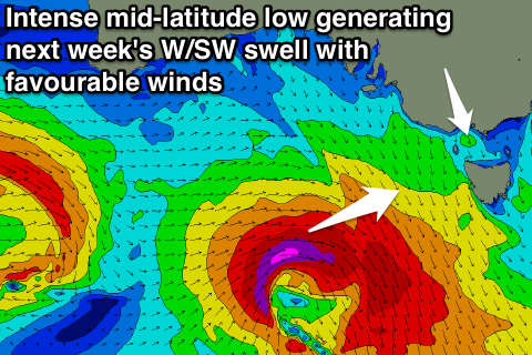
An intense mid-latitude low pushing in from the west and dipping south-east through our swell window should produce a moderate sized W/SW groundswell for Tuesday afternoon/Wednesday with favourable N'ly winds, but check back here on Friday for more information on this.
Comments
I live in another world:-D
MP shaping up quite nicely this afternoon.
Interesting too see sorell level out as of last night but this arvo seemed bigger, more solid than yesterday?
Yeah, I had another mate say the same, that's the super long-range groundswell energy, didn't think there'd be too much to it, see what this morning is like. Only very small but strong long-period signals on the buoys.
Its backed off again. 2-3ft now. Could shoaling come into play regarding yesterday?
Craig mate the WAms are going bezerk for next weekend and and the week after Friday 6th of May looks huge and both swells with offshore winds if that stays the same they look 6-8 ft swells check it out looking very nice
Yeah, been keeping a close eye, still shifting around a bit, but there's swell coming.