Great Surf Coast tomorrow and Sunday, large Monday with dicey winds

Victoria Forecast by Craig Brokensha (issued Friday 8th April)
Best Days: Surf Coast Saturday and Sunday, Torquay early Monday and early Tuesday, both coasts Thursday and Friday
Recap
Good clean 3-4ft sets on the Surf Coast yesterday, easing back a touch later in the afternoon as morning offshore winds tended more W'ly. The Mornington Peninsula was larger but average.
This morning the surf is clean again on the Surf Coast with 2-3ft sets, and better on the Mornington Peninsula around Portsea with 3-5ft sets. Conditions should remain clean all day as the swell steadies.
This weekend and next week (Apr 9 – 15)
Our two back to back pulses of SW groundswell for tomorrow are still on track. The first pulse for the morning should see good 3-4ft sets through the morning across the Surf Coast, building to 4-5ft at swell magnets into the afternoon, with the Mornington Peninsula due to build from 6ft more to 6-8ft.
Winds will be excellent for the Surf Coast with a moderate to fresh NW breeze through the morning, tending lighter W/NW into the afternoon. The Mornington Peninsula isn't looking as favourable with only a short-lived N/NW'ly early morning.
 A drop in swell is due into Sunday morning back to 3-4ft on the Surf Coast and 6ft+ on the Mornington Peninsula but gusty NW winds, will swing more W/NW through the afternoon and likely hold from the W into the mid-late afternoon but possibly become strong at times.
This strengthening W'ly wind will be related to the second strong burst of polar frontal activity up and towards us through this weekend.
A pre-frontal W/NW fetch of gales will generate an active sea state for a better aligned post-frontal SW fetch to move over, followed then by a stronger system projecting a fetch of severe-gale SW winds through our southern swell window Sunday.
A moderate SW groundswell pulse is due from the pre/post frontal fetch, building later Sunday back to the 3-5ft range on the Surf Coast and 6ft+ on the Mornington Peninsula.
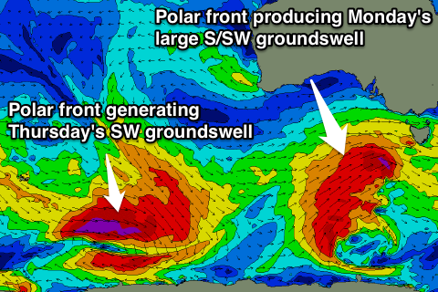
The S/SW groundswell is due to peak Monday with large 5-6ft waves on the Surf Coast and 8ft+ sets on the Mornington Peninsula.
Winds are looking less than ideal with a fresh and gusty SW'ly on Monday, but there's a high chance that the Torquay region will see a lighter W'ly early.
Tuesday looks to play out similar as the swell eases with an early morning W/NW breeze around Torquay, SW everywhere else. Easing 3-5ft sets are due, with 6ft+ waves on the Mornington Peninsula.
Wednesday looks like a good lay day with smaller surf and S/SE breezes.
Into the end of the week we're due to see a strong new long-period S/SW groundswell for Thursday with offshore N/NE winds.
This will be generated by a vigorous polar low being directed south-east from the Indian Ocean, into the polar shelf. A fetch of severe-gale to storm-force NW tending W/NW winds will be aimed along the Great Circle Path leading up towards us, resulting in a moderate sized SW swell.
The Surf Coast should see strong but inconsistent 3-4ft+ sets Thursday morning, with 6ft+ sets on the Mornington Peninsula, clean for most of the day. We'll have a better look at this Monday though. Have a great weekend!
Comments
Still plenty of decent sets in the 4ft range at 13th Beach this morning.
Hey Fellas, bloody great service and always some great banter / a bit to learn in the forecast comments section. Just a quick one, is today's large s/sw swell still on the cards or has it been downgraded a touch or running behind time? Cape sorell is on a slow rise but not much's happening on Pt Nepean as yet? Cheers in advance