Workable Friday, better next Tuesday

Victoria Forecast by Craig Brokensha (issued Wednesday 2nd March)
Best Days: Both coasts Friday morning, Mornington Peninsula Sunday morning, both coasts Monday and Tuesday
Recap
Conditions were good and clean across the Mornington Peninsula yesterday with a full and easing 3-4ft of swell, while conditions improved through the morning on the Surf Coast and more variable winds from the NE favoured the beaches. A smaller mix of SE and SW swell were breaking to 2ft+.
This morning the surf was super clean across both coasts but tiny, with the Mornington Peninsula the only decent option for a surf.
This week and weekend (Mar 3 – 6)
Tomorrow will be a lay day as the surf remains tiny and moderate onshore winds from the S/SE linger after an onshore change today.
Later in the day a new W/SW swell should start to show, with a better pulse for Friday morning.
These swells have been generated by back to back frontal systems, the first and weakest under WA, with a secondary stronger and better aligned system further south in our swell window.
The swell should kick later tomorrow and peak Friday with 2-3ft sets across most breaks on the Surf Coast, although the odd bigger one is likely at swell magnets, with 5-6ft sets on the Mornington Peninsula.
Conditions are still a little dicey but more than workable with a light onshore S/SE breeze, so keep your expectations low and you should enjoy.
A drop in size is due through Saturday as winds increase a notch from the S/SE, creating average conditions.
Sunday will be worth a look on the Mornington Peninsula with peaky small leftovers to 3ft or so as winds tend E/NE through the morning ahead of afternoon sea breezes. Mid-late morning will likely be best.
Next week onwards (Mar 7 onwards)
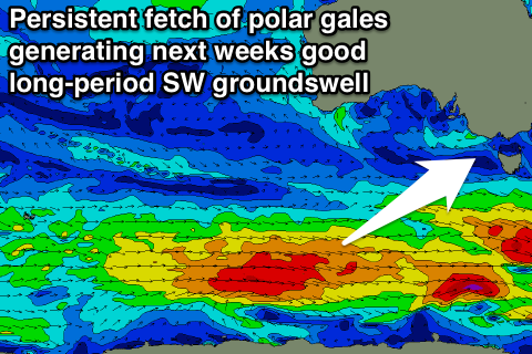
From Monday next week inconsistent but good fun pulses of SW groundswell are due across the the state from a flurry of strong polar frontal activity.
 The first pulse building Monday will be really inconsistent and small, generated by an initial fetch of severe-gale W/NW winds south-east of Heard Island during tomorrow. The Surf Coast is likely to be small and only around 2ft Monday morning, kicking to a better 2-3ft through the afternoon with building sets to 4-5ft on the Mornington Peninsula into the afternoon.
Good winds are due to develop across both coasts Monday morning with a N/NE'ly ahead of fresh SE sea breezes.
The best pulse of SW groundswell is due to build Tuesday, generated by a better and closer fetch of W'ly gales moving along the polar shelf from Friday through the weekend.
This should provide better and good 3-4ft sets across the Surf Coast with the odd bigger bomb likely at swell magnets, while the Mornington Peninsula should offer 5-6ft waves with the odd 8ft bomb.
Favourable N'ly offshores are expected again for most of the day, with NW winds Wednesday as the swell eases.
Longer term there's nothing too significant on the cards till the following weekend. More on this Friday.
Comments
Hey Craig,
What your current thoughts on the long weekend coming up Even though it's still a week and half away the wams look like there could be some swell. Hopfully some offshore winds to go with it !
Cheers
Where's the 'rolling eyes/stick needles in your ballsack' emocion when you need one................
I think the Easter long weekend is the one to wait for. Always has good surf.
Vic S1 . One word for long weekend . WET
Sorrell is spiking crazy in the period section. Do these buoys pick up forerunners or just glitch readings?
When the Cape Sorell buoy is "spiking crazy in the period section" like that, it usually infers a faint, intermittent leading edge of a distant swell.
The lack of significant increase in Tz (zero crossing) at the Cape Sorell buoy - also qualified by a lack of wind at the Cape Sorell AWS (which, if there was a frontal passage and subsequently strong onshores, could lower Tz values by contaminating the 'groundswell' with 'windswell'), also supports the suggestion that the new energy at Cape Sorell is a minor event.
I can understand it being a minor event but the reason it caught my eye is because at the moment were pretty much out of swell. So this morning spiking in period lead to believe the forecasted swell could actually be here by this arvo. I kind of understand about the Tz not rising and that strong winds can contaminate the Tz. I generally dont look at size on buoys but rather look at the periods.
Im so hopeless at trying to get whats out my head into words/speech..
Only spiking up to 15s, which is in line with the model, so I'd say forerunners of a mediocre swell
Mediocre trumps no swell :)
New swell looking good this morning and relatively clean.