Workable waves over the period, biggest Sunday afternoon but onshore

Victoria Forecast by Craig Brokensha (issued Wednesday 14th October)
Best Days: Thursday both coasts, Friday morning both coasts, Saturday morning Surf Coast, Sunday Surf Coast
Recap
Lingering onshore winds and a small 2ft of swell across the Surf Coast yesterday, with 4ft sets on the Mornington Peninsula.
Today conditions were much cleaner across both regions, but the swell smaller and best east of Melbourne with 3ft sets. The Surf Coast is small and around 1-2ft, best on the beaches.
This week and weekend (Oct 15 – 18)
A fun new W/SW groundswell is due into tomorrow with fresher N'ly breezes, locally offshore through the morning across both coasts, before tending a touch more N/NW into the late afternoon east of Melbourne.
The swell will be very inconsistent but should offer 2ft sets across the Surf Coast with 3-4ft waves on the Mornington Peninsula, mixed in with the odd 5ft bomb.
Friday's tricky swell is on track, but it looks to take a more W/SW direction than SW, and the forecast models are overcooking the size a little.
This swell will be generated by a small and intense, but unfavourably tracking low, moving in from the west today, aiming the smallest fetch of gale to severe-gale W/SW winds through our swell window.
Although the strength is there, the small nature of the low is only expected to keep inconsistent 2ft+ waves hitting the Surf Coast, with 3-5ft waves on the Mornington Peninsula.
Winds look workable early across the Mornington Peninsula with a light N'ly, but a shift to the NW is due mid-morning ahead of a fresh W/SW change before lunch.
 This change will be linked to a small and weak low pushing in from the west, and should again produce a small W/SW swell for Saturday in the 2ft range on the Surf Coast with 3-5ft sets on the Mornington Peninsula. Conditions will be best on the Surf Coast with a light W/NW tending W/SW breeze, although a more variable wind may be seen early on the Mornington Peninsula.
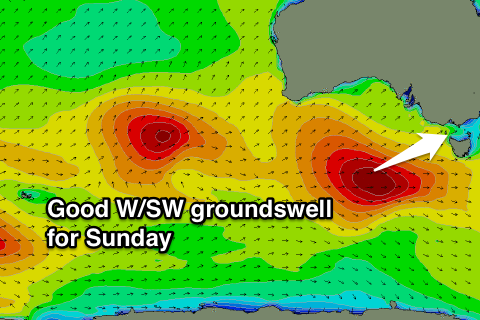
Of greater importance is the moderate to large sized W/SW groundswell due into Sunday across the state. This will be generated by a strong and powerful low firing up to the south-west of WA, pushing east while aiming a fetch of gale to severe-gale W/SW winds through our western swell window.
A strong consistent W/SW groundswell will result, building through Sunday and peaking into the afternoon to 4-5ft on the Surf Coast, with 6ft bombs likely at 13th Beach. The Mornington Peninsula should kick to a large 8ft+.
Winds Sunday are looking a little dicey as a high moves in after Saturday's weak change leaving lingering S/SE winds, that may be variable through the morning. Monday should be cleaner as the swell eases with N/NE offshores and SE sea breezes.
The secondary pulse of W/SW groundswell due into Tuesday/Wednesday has been downgraded, with the secondary low producing the swell, weakening well west of WA. This will only generate a small and inconsistent W/SW groundswell for Wednesday with what looks to be onshore winds.
Longer term some good SW groundswell is on the cards for later next week, but more on this Friday.
Comments
Some lovely looking waves at 13th Beach this morning.
Pumping!
Still some solid clean waves on the Morn Pen this arvo.
A few Dukes going down at TQ this morning.
moving down to geelong early next year.. can't wait to get amongst it