Extended run of excellent long period swells for Vicco

Victorian Surf Forecast by Ben Matson (issued Wednesday 30th September)
Best Days: Fri: buidling W/SW tending SW swell with NW winds in Torquay. Easing Sat. Sun: Building W'ly swells, only small in Torquay (comparatively) but clean under a NW wind. Easing slowly Mon. Tues: large building W'ly tending W/SW swell with great waves in Torquay: Easing slowly Wed. Tues onwards: Plenty more W/SW swell, with fun waves along the Surf Coast.
Recap: A new long range groundswell provided clean 2-3ft sets in Torquay on Tuesday though it was very inconsistent. The surf was bigger east of Melbourne, but conditions were less favourable here. Size has eased today with lingering onshore winds.
This week (Oct 1- 2)
No major change to the forecast notes issued Monday. The swell period charts are still showing two swell fronts for the coming days; one through this afternoon and another early Friday.
The first swell is still of little interest to me. It source was a pre-frontal NW fetch in the Indian Ocean over the weekend, located a very large distance from the mainland. At the time these notes were prepared (4pm), the Cape Sorell, Point Nepean and Cape du Couedic (SA) buoys had yet to detect any sign of new energy, and I’m really not expecting much to eventuate across Victorian beaches on Thursday. Surf size should remain small in Torquay (inconsistent 1-2ft sets for most of the day) and it’ll be clean early here with freshening N/NW winds ahead of a W’ly change before lunch.
East of Melbourne, there;’s a chance for a brief window of workable winds at dawn but it’s a dicey call at this stage with westerlies likely to be threatening early. There’ll be more size here but I’m just not comfortable that it’ll be worth any road mileage.
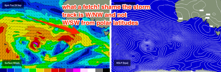
Friday’s new swell is much different. As outlined on Monday, the source is similar to Thursday's swell yet there are a couple of characteristics that will probably lead to a bigger, better, more defined swell event. First of all, the responsible fetch is located closer to the coast. Second, an embedded low developing within the W/NW thru’ NW fetch is expected to build on the already-active sea state. And thirdly, as the low reached maturity, the NW storm track is expected to tend straight W’ly, even nudge slightly W/SW for a few hours as it passes through the eastern periphery of our swell window.
So, I am reasonably confident that we’ll see a fun round of swell from this system on Friday, and the models are also keen on it which is a good sign (given the slightly tricky source). I think we’ll see a building trend all day towards a peak early-mid afternoon, with 2-3ft sets building to 3ft+ across the Surf Coast under a light to moderate NW wind. Note: it may be smaller at first light, as we’re not expecting the leading edge to arrive until about dawn (give or take an hour). However there should be a strong upwards trend by mid-morning.
Surf size will be much bigger east of Melbourne - somewhere between 4ft and maybe 6ft at exposed beaches by late afternoon - and winds are not expected to be too strong, possibly even tending variable in the afternoon. However I don’t think we’ll see enough size for Western Port so Flinders will be the only other nearby alternative if the beaches are maxing out.
This weekend (Oct 3 - 4)
Friday’s swell will then ease through Saturday, with mainly freshening NW winds favouring the Surf Coast for a small clean wave. These winds could prove to be problematic for the open beaches east of Melbourne, as current model guidance has it around 15-18kts. However we may see periods of more N/NW winds, which would be quite workable for the northern ends of the Peninsula and Island. Size should be around 4-5ft early, easing during the day.
Late afternoon, the leading edge of a new W’ly swell is expected to push through and this will dominate Sunday’s surf conditions with winds expected to remain from the NW, possibly tending W’ly at some point as a weak front slips south of the state (although there probably won’t be much strength in it). This new swell will originate from a sustained belt of NW winds on the eastern flank of a large Long Wave Trough in the Southern Indian Ocean. Swell periods will be quite strong thanks to several embedded features within the NW flow that are expected to display very strong winds in excess of 40kts.
Unfortunately, westerly swells often create very large ranges in wave heights across the coast, and with a risk for NW or W’ly winds we need to be cautious about surf prospects east of Melbourne. In any case I think wave heights will be too large for the open beaches (sets in the 6-8ft range) so you’ll need to aim for sheltered locations for the best surf.
Along the Surf Coast, we’re looking at much smaller surf due to the swell direction. I’d rather play down wave heights and be pleasantly surprised if it exceeds my estimates, rather than punching too high with the forecast, so I’m going to hold steady with 2-3ft across much of the Surf Coast on Sunday. However, the Bellarine Peninsula (Barwon Heads and surrounds) is more exposed to W’ly swells than the Surf Coast so it’ll be bigger here, maybe 3-4ft+ at times.
Let’s take once final pass at the numbers on Friday once the satellite observations are in for the responsible fetches. But for now, it’s looking like a fun weekend of waves.
Next week (Oct 5 onwards)
Sunday’s long period westerly energy will continue through Monday - I think we’ll see a similar size early morning before it tapers off into the afternoon. At this stage very light N’ly winds are expected so conditions should be great on all coasts.
On Tuesday morning, the leading edge of a very long period swell (Tp of around 22-23 seconds) is expected to make landfall. This will have been generated by the main engine room of the Long Wave Trough in the Indian Ocean, and we’re looking at an initial W’ly swell tending W/SW over the coming days.
Tuesday should therefore see a kick in size, and it’s hard to argue with the model guidance for 3-4ft surf in Torquay - sure, the W’ly swell will create another large range in size but this pulse looks bigger, with a larger period, and the storm track will be more favourable than what we’re expecting Sun/Mon. In fact, I would be surprised if it ends up being a little bigger than this across the Surf Coast reefs (maybe a peak around 4-5ft into the afternoon). East of Melbourne set waves should push 8ft+ by the afternoon. Winds are expected to remain from the northern quadrant at this stage.
The trend for Wednesday will be for slightly smaller surf, despite the swell direction swinging W/SW. Unfortunately, the latter stages of the storm cycle is expected to display much weaker winds in our near swell window, so I think the bulk size from this event will be mainly out of the west on Tuesday. That being said there should still be plenty of waves for the Surf Coast.
Looking beyond this, and a series of strong fronts through the Bight early in the week will then set up another round of smaller but equally favourable swells from Thursday through into the following weekend. It probably won’t be quite as big as what we’re expecting around Tuesday but should still be enough to keep the Surf Coast running with some fun clean peelers. More on this in Friday’s notes.
Comments
Small but nice and clean ahead of the change!
Ben the direction you show would push is straight into the west coast of tassie. Should be massive there (Marrawah).
Hi Ben / Craig,
I'd like to repeatedly ask you inane questions that can be answered by a cut and paste for the text above, with the thinly veiled purpose of wasting your time to the point where you shut down the forums on the forecast notes in frustration.
Yours truly, Cyclone Gary
let em fly gary, I don't even live in victoria but tune in weekly just to see how stupid and inane the questions can get, for some reason victoria forcast is the place for such little joys, small things...
Hey ben,
Around what time will the swell hit tommorow morning
There's one for ya sypkan!
Hi Ben,
What will the wind be doing on Saturday arvo? Which way should I kick if I win the toss? and do you think the swell will hold for the second half?
Go Hawks!
Good goofyfooty, what is the point of having a comment section if you get bagged by keyboard warriors every time you ask a question.
Well seeing as Ben has written "building all day with a peak early-mid afternoon", I'd say that would be your answer!! Wouldn't you?
Maybe read the forecast before you go asking rediculous questions..
You flog
We should carpool one day Baz I'm sure the trusty lads here will steer us in the right direction.
You my friend are a keyboard troll.
never disappoints
Ever
What retro hipster board would best be recommended for the weekend? My single fin or twinny and should I or should I not carpool to the island, peninsula or surf coast.
P.S. Any secret spots I should know about.
I'd suggest a 1920's 16 foot hollow ply board. You will certainly make the cover of the new alternate surf media, maybe even take Byron off the front cover for a bit. Why have a fin at all? Just a bit of vee through the tail, as Wally Froiseth said, a 'calculated drag'. 60's VW Beetle as the vehicle of choice, the board will protrude so take care on the highway.
As for the place - the world is your oyster, after all it's the most liveable city in the world! A certain point of a certain surf city town - imagine how you could thin the crowds by just letting go of it - just once - in the swell. Probably the sooner into the session the better. Hope this helps, apologies for being a bit cryptic. Like you I love the Vicco forecast notes.
Velocityjohno how would I fix a bayonet to a retro board? I think I got your cryptic description let me know when to deploy my weapon.
Um thermal ben, just wondering if you have been barreleld before? Regards ya dads ya barrel
And Goofy foot, ya dogs ya turtle :)
Don't think I'll be heading down to the surf Coast tomorrow due to a storm in port Phillip bay tonight. The strong winds will create a southerly swell with solid size building throughout the day and peaking some time in the arvo. The size at South facing beaches will be a from 2-4 foot but don't ask me which spots cause poeple will abuse you for asking a logical question. Any sand banks will be barreling of its tits and apparently surf coast will be bumhole tomorrow with 50 km onshore and sloppy conditions. There has also been a report that wherever goofyfooty goes for a kayake because he is a flog and can't surf, it will automatically make that surf spot sloppy.
Yeh I 100% agree Basel_baz. I recon goofy foot u just need to give it a rest mate and shut the fuck up. If you wanna take this to the next level u can meet me at Mornington car park for a one on one chon. So if I were u shut your nob and give your boyfriends dick a big hard suck. :)
I've been struggling recently trying to work out if some of these people are clever funny people taking the piss out of stupid people, or are just stupid flogs. Might be a mix of the two. If you're the former then i takes me hat off to you. If the latter then please do all of the rest of us a favour and shut up with the moronic questions.
Goofy , best you don't go to the big dance with ya dads barrel .
If I was game betting man with coin to burn on the long road , I'd be partying
with the Eagles boys come Sunday . Make sure you PaCk your : A party game , 4 2More . !
I think im picking up what you're putting down.. Might go for a drive Tuesday, you keen?
Coupla groms getting stuck into a small line at Lorne this AM.