Large swell incoming, best west of Melbourne

Victoria Forecast by Craig Brokensha (issued Friday 24th July)
Best Days: Surf Coast every day, experienced surfers only Sunday and Monday
Recap
Fun 2-3ft waves across exposed breaks on the Surf Coast with offshore winds, while the Mornington Peninsula was around 4-5ft and also clean. The swell pulsed stronger than expected through the afternoon though, reaching 3ft+ on the Surf Coast and 5-6ft+ on the Mornington Peninsula as winds tended more NE.
The pulse was only temporary though, with small to tiny easing waves left on the Surf Coast today and 3-4ft sets on the Mornington Peninsula.
This weekend and next week (Jul 25 – 31)
 Tomorrow's pulse of W/SW groundswell should be similar to yesterday's, although a spike like seen yesterday afternoon is less likely.
An inconsistent 2ft wave is due on the Surf Coast (possibly the odd bigger one at swell magnets) and 4-5ft+ waves on the Mornington Peninsula.
Winds are due to improve and swing from a fresh and gusty W/NW'ly around to the N/NW through the afternoon.
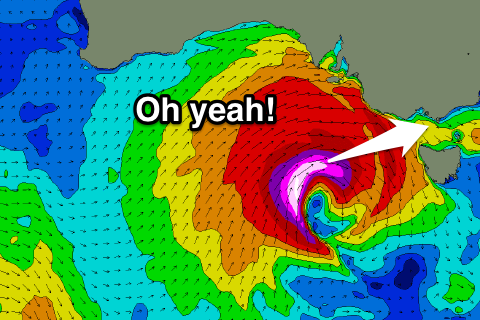
Sunday's mix of swells has now been upgraded, with the vigorous frontal system pushing in from the west now due to aim a fetch of severe-gale to storm-force W/SW winds through our western swell window, reaching up to 60kt around its core.
This will generate a large and powerful W/SW groundswell that's expected to fill in rapidly through the day Sunday, building to 6-8ft on the Surf Coast into the afternoon and 10-12ft on the Mornington Peninsula.
Winds will be strong from the W/NW tending W'ly all day Sunday, favouring the Surf Coast, but it will only be for experienced surfers.
Come Monday the swell will still be large and from the SW due to a secondary fetch of severe-gale SW winds being aimed through our south-western swell window Sunday.
The Surf Coast should still be in the 6ft range, easing into the afternoon and from 8ft+ on the Mornington Peninsula.
Conditions will remain best on the Surf Coast with a fresh W/NW tending W/SW breeze, favouring protected breaks.
Tuesday will be smaller again with early W/NW winds around Torquay and SW breezes everywhere else.
A new SW groundswell for Wednesday afternoon, and then stronger pulse for Thursday are still on track, generated by a vigorous polar frontal progression firing up in the Heard Island region Saturday and pushing east through Sunday and early next week.
An inconsistent pulse Wednesday afternoon is due to 3ft on the Surf Coast and 6ft on the Mornington Peninsula, with Thursday pulse offering better but inconsistent 4-5ft waves across the Surf Coast and 6-8ft sets on the Mornington Peninsula. Winds will swing more N/NW Wednesday and then be offshore from the NW early Thursday ahead of an onshore change through the day.
Longer term a larger SW groundswell is possible for next weekend, but we'll have a closer look at this on Monday. Have a great weekend!
Comments
Craig what time will the northerlies be settled in?
Not really going northerly at all. N/NW from about 4pm into the evening.
30 knot westerly sunday is a bit hardcore.
Yeah, tricky and bloody freezing! Cold air mass with this low and wind chill will make it really testing.
Hi bud I'm a keen windsurfer...going to hit a point break up on Sunday!!!! Are you able to tell if it's going to gusty w wind on sunday like all w winds usually are...or could it have some consistency....to me it looks like I could rig up a tea towel and sail...
Yep, should be no problem at all with wind strength and persistence!
:)
The water temp was ice-cream headache cold yesterday arvo. It will be even colder sunday, with a bit of a deep sea mix up, no sun and that surfers ear inducing wind. Can't wait, pumped!