Fun week for more exposed coasts

Victoria Forecast by Craig Brokensha (issued Monday 20th July)
Best Days: Tuesday both coasts, Wednesday east of Melbourne, Thursday both coasts (afternoon east of Melbourne), Friday east of Melbourne, both coasts Saturday
Recap
Poor conditions Saturday with a strong mix of swells and fresh S/SE winds, while Sunday was the day to surf, with clean 3-4ft easing waves on the Surf Coast and and 6ft sets on the Mornington Peninsula.
Today the swell was smaller and back to 1-2ft on the Surf Coast and 3-4ft on the Mornington Peninsula with great winds for both coasts.
 This week (Jul 21 – 24)
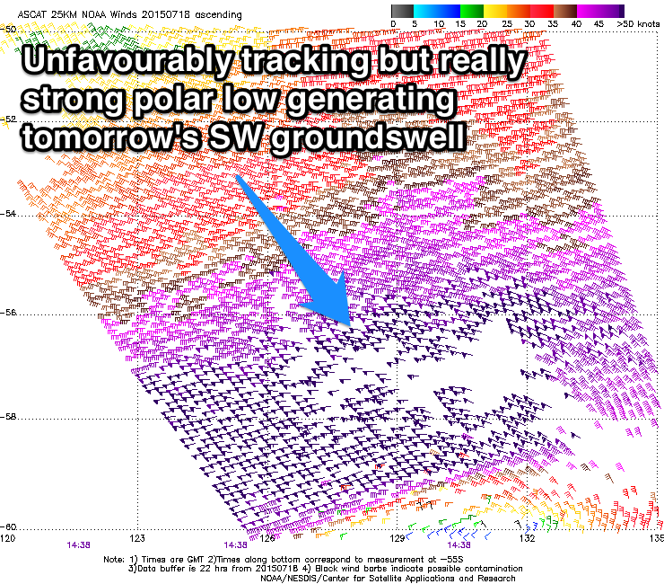
Our small spike in inconsistent SW groundswell is still on the cards for tomorrow, with a very strong but unfavourably tracking low generating it over the weekend. Satellite observations of the storm are hard to ignore though, and I've upgraded the expected size a little. The swell is due to arrive overnight and then peak tomorrow morning to 2-3ft on the Surf Coast and 4-5ft on the Mornington Peninsula before easing into the afternoon.
Winds will be best for the beaches on both coasts with a fresh to strong N'ly, tending N/NW at times on the Surf Coast and N/NE on the Mornington Peninsula.
Come Wednesday the swell will be tiny with fresh N'ly tending NW winds, favouring the Mornington Peninsula early with a small 3ft or so of swell.
Late in the day a new W/SW swell may be seen across both coasts, but Thursday will be a better chance of this.
The swell is being generated by a strong but very west in nature frontal system pushing into and under WA today.
With this westerly direction, only an inconsistent and smallish 2ft wave is due on the Surf Coast with larger 4-5ft+ waves on the Mornington Peninsula. Winds will be best across the Surf Coast through the morning and light from the NW, but a swing to the N/NE into the afternoon, will clean up the Mornington Peninsula, so there's no rush to surf early east of Melbourne.
A drop in size is due into Friday and early N/NE winds will favour the Mornington Peninsula with N/NW breezes into the afternoon.
This weekend onwards (Jul 25 onwards)
Into Saturday a better pulse of W/SW groundswell is due, compared to Thursday's, with a relatively weak but unfavourably tracking frontal system pushing towards SA, expected to be followed up by a secondary slightly stronger system pushing into us Friday.
This should produce a fun pulse of W/SW swell, building to the 3ft range on the Surf Coast and 5-6ft on the Mornington Peninsula under N/NW winds. The models are still diverging a little on this swell though, so lets have another look at this Wednesday.
Longer term a much stronger cold outbreak is due to move in Sunday/Monday bringing larger swell but with likely poor winds, more on this Wednesday.