Surf Coast the pick again

Victoria Forecast by Craig Brokensha (issued Monday 29th June)
Best Days: Tuesday morning and Wednesday on the Surf Coast, Friday morning Surf Coast, Saturday morning Surf Coast, Sunday Surf Coast
Recap
A late pulse of small but ultra-long period W/SW groundswell seen Friday peaked through Saturday with inconsistent but strong 3-4ft sets across the Surf Coast and larger waves on the Mornington Peninsula under favourable winds (best through the morning east of Melbourne).
Sunday morning started around a similar size, if not slightly bigger with 5ft sets across the Surf Coast and conditions were again great with offshore NW winds. An expected late kick in more consistent and larger W/SW groundswell from a vigorous polar low tracking quickly in from the west over the weekend came in around expectations with reports of easy 6ft sets at some spots and larger 8ft bombs on dark across the Surf Coast. The buoy data matches this with Point Nepean kicking to just under 4m Significant Wave Heights with peak periods above 18s. Conditions remained favourable into the evening as well as winds became variable from the west.
This morning the swell was still large and strong early across the Surf Coast with 4-6ft sets under offshore winds (8-10ft on the Mornington Peninsula). The swell will drop steadily through the day though as winds remain offshore.
 This week (Jun 30 – Jul 3)
The swell should ease further into tomorrow, but not drop below 3ft across the Surf Coast, with 6ft sets on the Mornington Peninsula as a reinforcing W/SW groundswell fills in.
This swell was generated by a pre-frontal fetch of W/NW gales, and will be replaced by a stronger pulse Wednesday morning, from a broader and stronger pre-frontal W/NW fetch currently south of the Bight.
A moderate sized SW groundswell should be generated, peaking Wednesday morning to 3-4ft+ on the Surf Coast and 6-8ft on the Mornington Peninsula before easing into the afternoon.
Winds will be best for the Surf Coast and offshore from the W/NW tomorrow morning ahead of a shallow W/SW change late morning/midday and then NW all day Wednesday (likely N/NW early on the Mornington Peninsula).
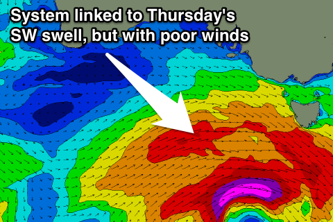
From Thursday and into the weekend we'll see all the frontal activity shift into our south-western swell window as a new node of the Long Wave Trough starts to develop just east of us, and across the entrance to the southern Tasman Sea.
This will direct a series of strong cold fronts initially up and into us (Thursday) before the activity shifts more into Tasmania and a touch further east, more in our southern swell window.
Thursday's front should bring with it a moderate to large kick in SW groundswell, building towards a peak through the afternoon to 4-5ft+ on the Surf Coast and 6-8ft on the Mornington Peninsula but a strong SW change associated with the swell will create poor conditions. The Surf Coast may see an early W'ly but the swell won't be fully there yet.
A drop in size is due Friday and lingering SW winds are due across most spots although the Surf Coast should see an early W/NW'ly.
This weekend onwards (Jul 4 onwards)
Thursday afternoon's swell is due to continue to ease into Saturday with favourable and fresh N/NW winds ahead of a S'ly change through the day, with some strong S/SW groundswell due into Sunday.
This will be from the polar frontal activity shifting more into our southern swell window, with a strong low forming south-southwest of WA Thursday and then swinging in and up into Tassie towards the weekend.
A solid 4-5ft+ of S/SW groundswell is due across the Surf Coast with 6-8ft sets on the Mornington Peninsula under N/NW tending NW winds. We'll have a closer look at the specifics of this swell on Wednesday though.
Comments
How's lorne on thursday
Yeah should have some fun small peelers into the afternoon.
Hey Craig,
Do you think it will go onshore tomorrow?
Had a look at the BOM and it looks like it will be S/W at 10 am.
Yeah looks like a shallow W/SW change now around late morning/midday. Will update.
It's so weak that we'll probably see winds tend variable into the mid-late afternoon once it passes though.
Hey Mr. Craig,
you think the last few lows that made this extended run of good waves, would have made near on epic surf for vicco if them high pressure zones didn't squeeze them out so much? Its been pretty good tho. Got good waves Wednesday, friday,Saturday, sunday and monday. 4 to 6 hours each day. It really brought me back to the good old days of being a hyped up grom running on weet-bix and stoke! Oh how the old body aches....
Will Lorne be the best bet on the surf coast Thursday morning?
Have you read the forecast?
If your goal is an overpriced coffee, sure Lorne will be the best bet on Thursday.
It seems like some readers would prefer to be told where to surf each day in lieu of a detailed forecast. In my opinion, the forecast gives too much information as it is. If someone can't choose somewhere to surf then they clearly need to do some more research and put in some effort. It will do you a lot of good in the long-run.
Please be a little more vague when forecasting. There's no need to talk about early morning wind patterns or late increases in swell. Those who put in the effort to do their own forecasting should be rewarded.
"There's no need to talk about early morning wind patterns or late increases in swell."
Erm, that's kinda what we specialise in.
Have you thought of Fishermans beach in Torquay? Reasonably priced coffee and great shopping at the surf shop outlets.
absolutely average
Pandering to the needs of kooks does this website no favors.
If people really need the sort of pin point accuracy in forecasts you are providing, it just proves how many chumps are clogging the lineups cos of your detailed hand holding nanny service.
Mate, the whole surf industry is built on "more chumps clogging the lineups". Its simple: More chumps = More money = Greedy bastards
Yip .if only coming off a surfboard was like a skateboard. Lineups be empty again
Man I dont know what is in the drinking water in Vic but this shit is hilarious, week after week "Craig, do you think i'll have enough fuel in my car to get to Lorne and back? and will i have time to sleep in a little bit before the sea breeze kicks in" I can see why the rest of you get the shits!
It's a bloody joke! I don't know if these questions get asked in the other forecast notes because I only read this one, but it's gotta be doing Craig's head in. It annoys me and I don't even have to answer them!
After the super detailed forecast that swellnet provides, people still have to go further and nominate themselves for kook of the week!
What is going on with you guys in Melbourne!? Thank fuck you mostly go to the west coast
There is very rarely a comment or question in the SA forecast notes. Probably because it only covers 2 average areas within an hour of adelaide that you could forecast a year in advance - flat on the mid, slosh down south. Occasionally yorkes or caml have secret code conversations with Craig but anyone asking how many weetbix to pack for a trip to cactus would get shut down. Seems like the surf coast is accepted as open slather.
Torquay is the main surf forecast region.
Talking about 13th Beach, Bells/Winki and Lorne Point is hardly open slather.
I hardly mention Bells/Winki in the notes either, just make reference to swell magnets etc some times.
People have asked before about other options away from Adelaide without giving too much away.
Sweet as mate, doesn't bother me i just get a laugh out of how pathetic some of the Qs are particularly on this region.
I do however, really enjoy reading a good scientific discussion regarding effects of tide, swell period, size and direction etc
Cheers.