Large easing surf with slowly improving winds

Victoria Forecast by Craig Brokensha (issued Wednesday 13th May)
Best Days: Early Thursday and Friday around Torquay, both coasts for keen surfers Saturday with a lingering onshore, Sunday both coasts, next week east of Melbourne
Recap
Large building onshore surf across the Mornington Peninsula, while the Surf Coast pumped most of the day, building from 4-5ft through the morning to a large 6-8ft through the afternoon and then a bigger 10ft+ on dark across swell magnets. Winds held from the W with strength into the evening, creating workable conditions across protected breaks for experienced surfers.
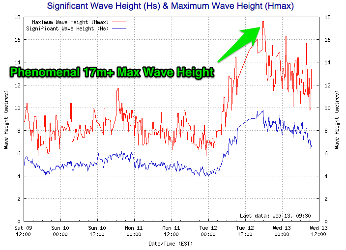
This large swell recorded some incredible figures with the Cape Sorell buoy off Tasmania recording a Maximum Wave Height of over 17m while Significant Wave Heights hovered just below 10m. This at incredible peak periods of 17 seconds indicated the significant nature of this swell event.
A peak was seen overnight with a drop in size back from a messy 6-8ft on the Surf Coast and 10ft+ on the Mornington Peninsula with poor winds. Torquay saw winds flirt from the W-W/SW at times this morning but in general conditions were poor.
 This week and weekend (May 14 - 17)
Last night's oversized W/SW groundswell will continue to ease into this afternoon and tomorrow, but a new reinforcing SW groundswell is due tomorrow, generated by a strong polar front currently pushing up and into us.
This should keep 6ft sets hitting the Surf Coast tomorrow morning with 8ft waves on the Mornington Peninsula before easing late afternoon and further down from 3-5ft and 6ft+ respectively Friday morning.
Come Saturday the swell will continue to ease, but a new pulse of SW groundswell is due through the late afternoon, generated by a polar low today and tomorrow, generating a fetch of gale to severe-gale W/NW winds through our swell window.
This should keep inconsistent 3ft sets hitting the Surf Coast late in the day with 4-6ft waves on the Mornington Peninsula, before easing from 2-3ft and 4-5ft respectively Sunday morning.
Winds will be an issue into the end of the week with fresh to strong but easing SW winds tomorrow and moderate to fresh SW winds Friday. The Torquay region should see periods of early W'ly winds both mornings, favouring the protected reefs.
Come the weekend, a lighter breeze is due, but this looks to linger from the S/SE, creating less than perfect but workable conditions.
Sunday looks much better with local offshore winds from the north, tending light and variable into the afternoon. This will finally open up the Mornington Peninsula for business.
Next week onwards (May 18 onwards)
Monday will only be decent east of Melbourne as the weekend's swell continues to fade from 1-2ft on the Surf Coast and 3ft+ on the Mornington Peninsula under NE winds.
Into next week a good pulse of S/SW groundswell is due Tuesday followed by a secondary pulse later in the week from a series of small polar fronts tracking along the Antarctic Shelf. Persistent N'ly winds will create clean conditions across both coasts, but the size may become too big for the Mornington Peninsula beaches.
Longer term we may see some better frontal and swell activity from the week starting the 25th of May, but more on this Friday.