Fun weekend, good swell early next week but onshore

 Victoria Forecast by Craig Brokensha (issued Friday 13th February)
Best Days: Saturday morning (early east of Melbourne), Sunday both coasts, Thursday morning east of Melbourne, Friday east of Melbourne
Recap
The swell picked up through yesterday but as expected conditions were poor with a fresh and gusty onshore wind.
Today winds swung around to the E/NE on the Mornington Peninsula in line with forecasts, but the Surf Coast performed a lot better than expected with a light variable breeze from the NE to E/NE favouring the beach breaks. A mix of easing SW and SE windswell was in the water offering plenty of workable peaks.
This weekend (Feb 14 - 15)
The weekend is looking fun for waves across both coasts, but locations east of Melbourne will offer the most bang for your buck (more so Sunday).
Today's easing W/SW groundswell will continue to drop into tomorrow back from 2ft on the Surf Coast and 3-4ft on the Mornington Peninsula, with an inconsistent W/SW groundswell kicking the swell back to this size for Sunday morning.
Tomorrow will be clean across the Surf Coast with a N/NW breeze but you'll have to get out early east of Melbourne as N/NE winds at dawn are due to swing N/NW through the morning and then S'ly into the afternoon.
Sunday morning should then offer a bigger window of favourable conditions east of Melbourne with a N/NE breeze due to persist into the early afternoon and only tend variable into the mid-late afternoon.
The Surf Coast will be best on the beaches with a N'ly tending N/NW breeze.
Next week onwards (Feb 16 onwards)
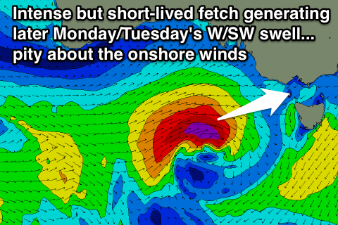
Our good pulse of W/SW groundswell due to build Monday is still on track, and we should see it hold at size longer into Tuesday and Wednesday with a slight upgrade in the strength of the frontal system generating it.
A mid-latitude low currently south-west of WA will push east over the weekend, aiming a fetch of strong to gale-force SW winds through our western swell window. Come Sunday though the low is now forecast to intensify just of the South Australian coast, aiming an additional fetch of severe-gale W/SW winds towards us.
This should result in a moderate + sized W/SW groundswell being generated that will arrive later Monday and peak overnight before easing slightly Tuesday and further into Wednesday.
The Surf Coast should pulse to 3ft+ late in the day Monday with 6ft+ sets, holding into Tuesday morning. The Surf Coast on Tuesday though is expected to drop a touch from 3ft and further down from 2-3ft Wednesday.
Unfortunately winds will be onshore through this whole swell event with an onshore change moving through Monday from the W/SW tending SW, S/SW Tuesday and then S/SE Wednesday.
Thursday and Friday will be the days to surf next week as winds clock around to the E/NE on the former and then N'th on the latter. A new long-range SW groundswell is also due to fill in Thursday, generated by a strong but slow moving polar low to the south-west of WA over the weekend.
The large distance from us won't be favourable with the swell due to be really inconsistent and lose a bit of size, but we should see infrequent 2-3ft sets at exposed breaks on the Surf Coast and 4-6ft waves on the Mornington Peninsula before easing back Friday.
Longer term we may see a secondary good groundswell for the weekend, but we'll review this Monday. Have a great weekend!