Morning windows of good waves over the coming week

Victoria Forecast by Craig Brokensha (issued Monday 15th December)
Best Days: Every morning Surf Coast, locations east of Melbourne early Tuesday, Thursday and Sunday morning
Recap
Saturday was great across both regions with a strong kick in swell to 3ft+ around Torquay and 3-4ft at 13th Beach while the Mornington Peninsula was too big for the beaches and in the 6ft+ range. Conditions remained relatively good into the afternoon as winds tended variable on the Surf Coast and remained offshore to the east.
Early Sunday morning was clean again across both coasts with a dropping 2-3ft of swell on the Surf Coast and 4-5ft sets on the Mornington Peninsula but onshore winds kicked in around 8am, writing off the waves for the rest of the day.
Yesterday's onshore change weakened through the night and today, lighter and more variable winds were seen but still onshore from the south with a leftover 2ft of swell across the Surf Coast and 3-5ft on the Mornington Peninsula.
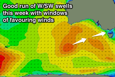 This week (Dec 16 -19)
Tomorrow morning will be clean early across both coasts with local offshores but a freshening NW'ly through the morning will favour the Surf Coast before becoming strong from the W/NW towards evening.
The swell is expected to be small and in the 2ft range on the Surf Coast and 3-5ft on the Mornington Peninsula ahead of an increase in new inconsistent W/SW through the day to 3ft on the sets and 5-6ft+ respectively.
This long-range energy from below West Oz and the Bight will be mixed in with some bigger close-range swell through Wednesday as the front pushing through the Bight and across us Tuesday evening strengthens while moving in from the west. A burst of W/SW-SW gales through Bass Strait is due to generate a medium sized SW swell for Wednesday morning with both swells coming in at 3ft+ on the Surf Coast and 6-8ft on the Mornington Peninsula.
Winds should dip back to the W/NW-NW across the Surf Coast Wednesday morning creating clean conditions before swinging onshore to the S/SW through the mid-late morning.
The W/SW swell should hold well into Thursday from a fetch of SW gales on the tail of the front pushing through the Bight, keeping the Surf Coast up around 3ft with 5-6ft waves on the Mornington Peninsula. A new W/SW swell should arrive later in the day though from another front pushing in behind the system moving through the Bight, keeping both coasts up around a similar size through Friday.
Winds however will only be favourable early Thursday east of Melbourne as a N/NE'ly at dawn swings fresh W/NW through the morning, favouring the Surf Coast and then strong W/SW into the mid-late afternoon. Friday will be best around Torquay with an early W/NW'ly ahead of a SW change mid-morning.
This weekend onwards (Dec 20 onwards)
The weekend looks fun with easing levels of W/SW swell under light N/NW winds Saturday morning and then the arrival of a new SW groundswell through Sunday with N/NE to SE winds. The SW groundswell is due to build through the day, so the beaches on the Mornington Peninsula should be fun and around 3-4ft before kicking to a larger 5-6ft through the afternoon.
Beyond this the outlook for Christmas week isn't too special with onshore winds after a change Monday expected to persist into Tuesday and Wednesday before becoming more variable Thursday but with no significant swells. More on this Wednesday though.