Good swell and northerly winds Saturday, small window also Sunday

Victoria Forecast by Craig Brokensha (issued Wednesday 10th December)
Best Days: Saturday morning both coasts, Sunday morning both coasts
Recap
Yesterday started poor with moderate to fresh onshore winds and small amounts of swell, but the afternoon saw much improved conditions as winds backed off creating cleaner 1-2ft sets at exposed spots on the Surf Coast and 2-3ft waves on the Mornington Peninsula.
Today winds tended more favourable for locations east of Melbourne with a clean 2ft+ of inconsistent SW groundswell while the Surf Coast was tiny.
 This week and weekend (Dec 11 -14)
Tomorrow will be another poor day of surf as a late onshore S/SE change this evening strengthens into tomorrow kicking up a weak S/SE windswell on the Surf Coast.
Winds should swing more E/SE into Friday but be fresh and gusty and with no decent swell across the Mornington Peninsula it'll be worth giving a miss.
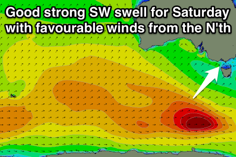
Our good pulse of SW groundswell with favourable winds for selected locations is still on track for Saturday. A strong polar low pushing in over an already active sea state to the south-west of WA will generate an inconsistent but strong SW groundswell for Saturday peaking at 3ft+ through the day on the Surf Coast and 5-6ft+ on the Mornington Peninsula.
Winds will be best for the beaches on the Surf Coast and locations east of Melbourne with a fresh and gusty N/NE'ly during the morning ahead of a fresh E/SE sea breeze. There'll also be some peaky SE windswell in the mix west of Melbourne creating some tasty wedges across the beaches!
Sunday is now looking good for a brief period across both coasts as the SW groundswell eases from the inconsistent 2-3ft range on the Surf Coast and 4-6ft on the Mornington Peninsula under early local offshores before a trough moves across us bringing a weak S'ly change.
So an early surf across both regions will be well worth the effort.
Next week onwards (Dec 15 onwards)
Monday morning will be smaller again and workable across both coasts with a light variable breeze before a fresher S'ly develops.
From Tuesday we're looking at some better swell activity again as a series of relatively weak cold fronts push up and towards us through the Bight from tomorrow onwards.
An initial pulse of W/SW groundswell is due Tuesday afternoon ahead of a larger pulse Wednesday to the 3ft range on the Surf Coast and 5-6ft range on the Mornington Peninsula.
Winds unfortunately will swing onshore in the wake of one of the fronts pushing across us Tuesday and then linger form the S'th into Wednesday. Thursday may be better, but we'll review this again Friday.