Small to moderate swell pulses with easterly winds

Victoria Forecast by Craig Brokensha (issued Wednesday 26th November)
Best Days: Every morning from Saturday at protected spots east of Melbourne
Recap
A fun pulse of W/SW swell filled in yesterday to 2-3ft across the Surf Coast with favourable W/NW winds for the Torquay region. Today the swell has eased back to the smaller 2ft range west of Melbourne although 3ft sets were reported at selected spots under light offshore winds. The Mornington Peninsula was still average with the westerly breeze while Phillip Island performed better.
A slight kick in SW swell is due during the day and this should keep similar sized surf hitting both coasts into the afternoon but an onshore change around midday will create poor conditions.
 This week and weekend (Nov 27- 30)
Tomorrow and Friday will remain average as onshore winds persist in the wake of today's change from the S/SE tomorrow and SE to S/SE Friday. The swell will also be on the ease with no real recommendations for a wave.
Moving into Saturday, a slight pulse of long-range SW groundswell due Friday evening should provide OK waves across protected spots east of Melbourne as winds swing to the E during the morning. It won't be perfect but there should be some OK 3-4ft peaks about.
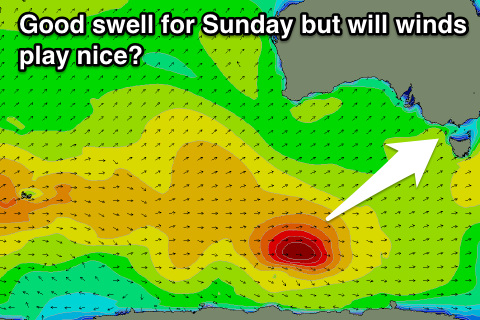
A much better long-range SW groundswell is due into Sunday, generated by a strong polar low skirting around a broad and stationary high sitting to our west.
A fetch of severe-gale W/SW winds will be generated through our south-western swell window producing a good SW groundswell for Sunday morning, peaking to 2-3ft on the Surf Coast and 4-6ft on the Mornington Peninsula.
Winds are still moving around a bit as an inland surface trough stalls around the South Australian and Victorian border resulting in persistent winds from the east. At this stage we're looking at probably E/NE winds Sunday morning favouring the Mornington Peninsula and then fresher E'ly winds persisting into Monday and Tuesday as the swell eases.
This isn't ideal and will favour more protected beaches east of Melbourne. We'll have one final, look at the winds for Sunday and Monday on Friday though.
Next week onwards (Dec 1 onwards)
As touched on above, Sunday's swell will ease through Monday and Tuesday likely under fresh E'ly winds, with a new small swell due into Wednesday. This swell will arrive from a similar source as Sunday's, that being a polar low skirting around the blocking high to our west, but it won't be as intense and only peak around 3-4ft+ or so.
Winds may lighten off and swing more E/NE, but we'll have to review this again Friday.
Comments
Morning Gents!
How we feeling about those winds for Monday, still seem all over the shop.....
Cheers
Oh man, yep still very hard to pick, looks like a change moving through now at some stage Monday afternoon. Better staying at exposed spots to the east than further west as winds will swing earlier over the other side.
Thanks again Craig!
Hi Ben/Craig, WAMS don't seem to be working for Japan and Hawaii.
East coast Oz WAMS working fine.
Lots of surf here, shitty winds though.
Ah, must be between uploads, should be there in an hour or so Zen. I remember looking at that system, looks better on the backside as winds go more NW?
Cheers Craig, judging by your report, Saturday and Monday looking the goods.
Now we all just need to do is collectively pray to the snow gods. Not much on the radar in that regard.
Yeah right on! Tomorrow morning in northern corners as well with that light NNE breeze forecast likely to swing locally offshore through the morning and remain variable until midday. Could still be a bit solid but.
Oh, and WAMs updated now.