East of Melbourne Tuesday/Wednesday, Surf Coast Friday

Victoria Forecast by Craig Brokensha (issued Monday 22nd September)
Best Days: Tuesday and Wednesday morning east of Melbourne, Friday and Saturday mornings on the Surf Coast, Sunday east of Melbourne
Recap
The only real chance for a decent wave across the Surf Coast was dawn Saturday with an early W'ly wind and small leftover 2ft of swell. Sunday morning saw more size but unfortunately a lingering S/SE'ly overpowered an local land breeze effects on the Surf Coast, while the Mornington Peninsula remained less than ideal.
Yesterday morning's long-range W/SW groundswell has since eased, with small and clean 2ft waves left over into this morning on the Surf Coast, while the Mornington Peninsula was great and in the 3-5ft range. The swell should to drop into this afternoon as sea breezes kick in.
This week (Sep 23 - 26)
The Mornington Peninsula will be the pick of the coast again tomorrow with small waves through the morning ahead of a long-range and very inconsistent W/SW groundswell through the day. This swell, generated in our far swell window isn't expected to get above an infrequent 2ft across the Surf Coast into the afternoon with 3-5ft waves on the Mornington Peninsula.
Winds should be good and locally offshore from the northern quadrant through the morning before tending variable into the afternoon.
A better S/SW groundswell for Wednesday, generated by a late forming but deep polar low to our south-west has been downgraded a touch, with the low forming even more later than ideal.
Still satellite observations have confirmed a fetch of storm-force W/NW winds within our swell window, with some S/SW swell spreading up radially from the low.
We should see this swell peaking Wednesday morning to an inconsistent 2ft+ on the Surf Coast with 3-4ft waves on the Mornington Peninsula under fresh N'ly winds ahead of a possible late afternoon change.
This change will be linked to a weak surface trough moving across us and with it we'll see poor and fresh SW tending W/SW winds on Thursday with another small building SW groundswell.
Friday is looking much better as winds revert back to the NW across the Surf Coast and W/NW along the Mornington Peninsula as another super long-range but good sized W/SW groundswell fills in.
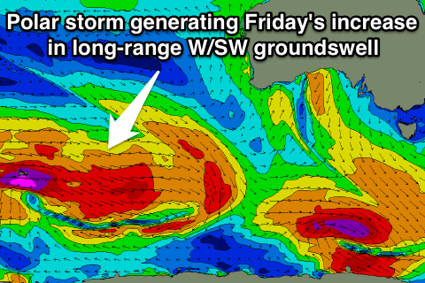 This swell has and is continuing to be generated in our far swell window to the south-west of WA, with a trailing and weakening front racing closer towards us and under the country tomorrow and early Wednesday.
A medium sized but inconsistent W/SW groundswell is expected, arriving early Friday and building through the day towards a peak into the afternoon.
The Surf Coast should build to an inconsistent 3ft+ with 4ft sets at swell magnets and 6ft+ sets developing on the Mornington Peninsula.
Winds will unfortunately go onshore from the W/SW at the peak of the swell, but the morning should still be fun.
This weekend onwards (Sep 27 onwards)
Friday afternoon's kick in W/SW groundswell will slowly back off into Saturday, with a reinforcing SW swell slowing the easing trend ahead of a more steady drop through Sunday.
The Surf Coast should ease from an inconsistent 3ft+ with 6ft sets on the Mornington Peninsula under NW tending NE winds and the stronger N'ly winds Sunday as the swell continues to drop.
Longer term we are looking at a larger W/SW groundswell for early to mid next week as a vigorous polar front is projected from the south-west of WA right up towards us early next week, but more on this Wednesday.