Surf Coast the pick for at least the next week

Victoria Forecast by Craig Brokensha (issued Wednesday 30th July)
Best Days: Thursday, Friday up until early afternoon, early Saturday around Torquay, Sunday, Monday
Recap
Medium sized levels of inconsistent W/SW groundswell held into yesterday morning to 3ft on the Surf Coast and 6ft+ on the Mornington Peninsula under strong N/NW winds. A slight increase in size was seen through the afternoon across both coasts but it wasn't until this morning that the larger W/SW groundswell started to show with the Surf Coast coming in at a clean 4-5ft with the odd bigger bomb at Bells and Winki while the Mornington Peninsula was a large 8-10ft.
We should see the swell muscle up a touch further through the middle of the day as the swell peaks, but it will probably be under the forecast 6ft+ on Monday across the Surf Coast with the fetch generating the swell coming in a touch more west than ideal. Still we should see 4-6ft surf west of Melbourne at exposed breaks as winds persist from the NW.
This Thursday through this weekend (Jul 31 - Aug 3)
Today's strong W/SW groundswell should dip overnight with a temporary low point in activity seen tomorrow morning. In saying this the Surf Coast should still be in the 3-5ft range with larger 8ft sets on the Mornington Peninsula.
Into the late afternoon though, a new SW groundswell is due, generated on the tail of the vigorous front responsible for today's swell. This swell will be a touch less consistent but from a better SW direction and size wise is likely to come in similar to today.
Only a late kick in size is due tomorrow, likely to 4-5ft on the Surf Coast ahead of a peak Friday morning to 4-6ft. The Mornington Peninsula should see 8ft+ sets.
Winds will remain favourable for the Surf Coast right up until the early afternoon Friday with strong N/NW tending NW winds tomorrow and then NW winds ahead of a S/SW change mid afternoon Friday.
This change will be linked to another large pulse of W/SW groundswell late in the day and more so Saturday. A vigorous polar front will that's currently forming south-southwest of WA along the Polar Shelf is forecast to be projected up towards SA by the Long Wave Trough, just on the edge of our swell window while producing winds in the severe-gale-force range.
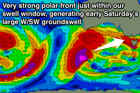 A very large swell will be produced for SA, with large W/SW side-band energy making its way towards as, kicking late Friday albeit with onshore winds and peaking Saturday morning to 6ft across the Surf Coast with 8ft bombs possible at swell magnets and then 10ft to possibly 12ft on the Mornington Peninsula.
Winds are looking a touch better now for the Surf Coast with an early W'ly likely around Torquay, favouring selected breaks, while everywhere else will be poor with a fresh but easing S/SW breeze.
Saturday morning's swell will drop quickly through the day, and Sunday will be left with medium sized levels of easing W/SW swell under NW tending W/NW winds, creating fun waves across the Surf Coast.
Next week onwards (Aug 4 onwards)
There's plenty more swell on the way for next week with another couple of medium to large sized W/SW groundswell on the cards for early to mid next week, but we'll discuss this more on Friday.
Comments
Holy smoke batman, anyone seen the size of the swell hitting SW Oz?
Vic SW (Port Campbell report) 25ft+ 8.8m@17s.
And Tassie SW Cape this morning was forecast as 40ft+ 11.2@15.2s.
Plenty hitting south oz as well.
I am no expert on reading swells, but can someone explain why the south coast is forecast at 12-15 feet (which is incredible) with a 5.6 meter primary and the mid coast is 4 feet (also pretty incredible) but with a primary of 9.7 meters.
In short (because it's a very complex topic): we have a different algorithm to predict 'surf size' for the Mid Coast, compared to the South Coast.
The reason for the difference in primary swell size is even more complex, as we've had to work around the limitations of global wave models (and how well they can resolve coastal features).
However there's a couple of additional factors at play here: (1) swell models struggle when there are a mix of swell trains in the water that are of a similar size/period/direction (as we're execting over the coming days), often merging them all into one large swell train, and (2) the swell shadowing offered by Kangaroo Island throws many more curveballs into the mix for both coasts (and can nudge the swell direction, as it seems to be doing at Victor on Friday).
However on the whole I think the automated prediction isn't too far off for Victor - certainly won't be 15ft but there's a good chance it'll be well over 10ft at exposed spots (not that there is anywhere likely to handle this size). And the Mid should be around 4ft too. So our algorithm seems to be working reasonably well with the available data.
That being said, we've got a few adjustments to make for the Mid Coast algorithm in the coming weeks, as it's undercalling small, long period swells a little. We're also making some tweaks to the global wave model too and we're not sure what effect they'll have so we'll have to monitor it closely. However we'll let everyone know when this is happening.
I've asked this question before and I must admit even with the explanation above I'm still not 100% clear.
I've found that the SN primary swell forecasts for the Mid tend to track pretty closely to the CdC Buoy readings.
eg this morning SN predicts 8.9m and CdC is reading around 8-8.5m.
Yeah, the Mid Coast ocean data point has a similar degree of exposure to the CdC buoy (the model doesn't resolve very well through Investigator Strait, or into either of the gulfs, so we had to create a workaround solution).
Victor's ocean data point is however a different location that is generally quite sheltered from all but straight S'ly or S/SW swells.
Well thanks ben, clear as mud.
Thought KI would have something to do with it.
Not doubting your wave size predictions by the way as I find them pretty good.
Just confused on the varying swell size compared to wave height.
Myponga Friday, or maybe a few little coves west of Victor????????
Both? Myps early and then a quick 30min drive over the hill towards Victor. Done that a few times, haha.