Large pumping swells to end the week, snow over weekend

Victoria Forecast by Craig Brokensha (issued Wednesday 25th Jun)
Best Days: Thursday protected spots on the Surf Coast, Friday (afternoon east of Melbourne), Saturday morning on the Surf Coast, early Sunday on the Surf Coast, Monday morning on the Surf Coast
Recap
The beginning of a large mix of W/SW groundswell and windswell were seen yesterday morning with clean but mixed 3ft waves across the Surf Coast and larger 6ft surf on the Mornington Peninsula.
By mid-morning though the swell kicked considerably, pulsing to an easy 6-8ft on the Surf Coast and who knows how big on the Mornington Peninsula as severe-gale force winds moved through Bass Strait. The Point Nepean wave buoy jumped to an incredible 10m maximum wave heights, but options were limited to only super protected breaks.
Today the swell has settled down a bit but conditions are improving across the Surf Coast with a fresh and gusty W/NW wind. This afternoon is looking excellent as winds tend more NW and the swell dips away a touch further.
This week (Jun 25 - 27)
Large levels of W/SW groundswell will persist into tomorrow and Friday as a vigorous frontal system currently moving in from under WA and the Bight projects a fetch of severe-gale to storm-force W/SW winds towards us.
This front will race slightly ahead of the swell its creating, with an initial increase in short-range W/SW swell due tomorrow morning ahead of the stronger W/SW groundswell into the late afternoon and more so Friday morning.
Size wise the Surf Coast should persist in the 4-6ft range most of the day before possibly kicking larger near dark, while the Mornington Peninsula should persist around 8ft+. Winds should be fresh to strong from the W/NW most of the day, creating great waves on the protected reefs around Torquay.
A peak in swell is due Friday morning with pumping but easing 6ft to occasionally 8ft waves due on the Surf Coast and larger 10ft+ waves on the Mornington Peninsula under fresh to strong N/NW winds. We should see winds tending more N'ly across the Mornington Peninsula into the afternoon, opening up more options for experienced surfers.
This weekend onwards (Jun 23 onwards)
Saturday morning will start off good across the Surf Coast with a clean 3ft to possibly 4ft of swell under fresh N/NW winds.
A deep mid-latitude low pushing in from the west though should move through during the late afternoon and with this we should see a late kick in new W/SW groundswell as a fetch of W/SW gales are aimed into us.
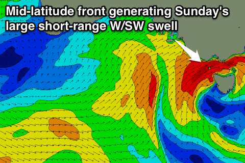 This should generate another large W/SW swell for Sunday and more snow for the alps, with a trailing fetch of SW winds kicking the direction around more to the SW on Monday. The models are still a little divergent on the strength of this front along with its timing but we're likely to waves in the 6ft range on the Surf Coast and bigger 8ft sets on the Mornington Peninsula under strong SW winds.
Monday could see an early W'ly across the Surf Coast as the swell eases out of the SW, but we'll review this again on Friday.
Comments
Satellite observations of the frontal system generating Friday morning's large groundswell have just come through from this afternoon.
Swell looks to be peaking overnight but early morning Friday should still see 6-8ft sets at Bells/Winki