Late Wednesday and early Thursday on the Surf Coast

Victoria Forecast by Craig Brokensha (issued Monday 2nd June)
Best Days: Tuesday morning, later Wednesday and early Thursday around Torquay, Friday morning for keen surfers
Recap
Friday's swell eased back into Saturday leaving tiny slow waves on the Surf Coast and better but lumpy 3-4ft waves on the Mornington Peninsula with a light variable wind.
A slight kick in new W/SW swell was seen on Sunday and conditions improved a lot quicker than expected with a surface trough moving across us earlier than forecast on Friday. This resulted in light offshores on the Mornington Peninsula, while the Surf Coast saw light to moderate onshore winds early before tending variable during the day.
Today, a new long-range W/SW groundswell has filled in with inconsistent but glassy 2ft waves around Torquay, 3ft sets at 13th Beach and 4ft to occasionally 5ft sets on the Mornington Peninsula under light variable winds. Make the most of this morning's clean conditions as a weak SW change is due through the afternoon.
This week (Jun 2 - 8)
Tomorrow and Wednesday morning should play out similar to today size wise, with a small-medium sized reinforcing W/SW groundswell. Winds look a little funky but should be variable again in the morning before increasing from the West during the day.
Wednesday will be best west of Melbourne with a fresh NW tending W/NW breeze and small 2ft or so of swell during the morning. Into the afternoon though a new W/SW groundswell is due and this swell will have a bit more size and power compared to the last run of swells.
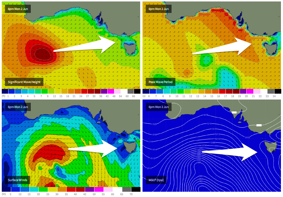 A mid-latitude moving in from WA through today and tomorrow will generate a fetch of W/SW gales through our swell window as it slowly moves east towards us. A medium sized W/SW groundswell should result that's expected to build later Wednesday and peak Thursday morning.
Size wise the Surf Coast should see 3ft waves with 4ft sets at 13th Beach and Bells/Winki, while the Mornington Peninsula should offer larger 6ft to occasionally 8ft sets. Winds are looking a little dicey though Thursday morning and from the SW to S'th as a shallow change moves through, but early morning around Torquay there should be a W'ly offshore.
Friday should be a touch better on the Mornington Peninsula as the swell eases with a light variable breeze due to develop across both coasts through the morning offering glassy/lumpy conditions.
This weekend onwards (Jun 9 onwards)
The weekend isn't looking too flash unfortunately as a cold front moves through during the day Saturday kicking up a low quality windswell for Sunday but with fresh to strong but easing S/SW winds.
Saturday morning will offer a window of clean conditions on the Surf Coast but there won't be much size about over a very inconsistent 2ft on the sets.
Longer term the outlook still remains average with a large blocking high expected to move in from the west and deflect any major swell generating systems away from us. Therefore make the most of Wednesday afternoon's and Thursday morning's waves and check back here on Wednesday for the latest update.