Patchy period; next Thursday looking decent

Victoria Forecast by Craig Brokensha (issued Friday 30th May)
Best Days: Saturday morning east of Melbourne, Monday morning for keen surfers, Thursday on the Surf Coast
Recap
Both regions offered OK waves yesterday with a small 2ft of swell on the Surf Coast and 3-4ft lumpy waves on the Mornington Peninsula under variable winds. Today the swell has dropped back a touch and NE winds are favouring the Mornington Peninsula.
An additional slight increase in W/SW swell is due this afternoon as sea breezes develop, with no real decent options for a wave.
This weekend (May 31st – Jun 1)
If you're planning to surf this weekend, head east of Melbourne and try and get a wave in Saturday as Sunday will be onshore and poor.
Size wise there isn't expected to be too much across the coast with this afternoon's increase in W/SW swell due to ease from 1-2ft on the Surf Coast and 3ft or so on the Mornington Peninsula. Try and surf through the morning with an offshore NE wind before SE sea breezes kick in.
Sunday will provide more size as a new W/SW groundswell fills in but a moderate to fresh SE breeze during the morning will create poor conditions. Winds should ease into the afternoon as the trough responsible for the SE wind slips slightly west.
Next week onwards (Jun 2 onwards)
Monday is now looking better, as the trough is forecast to hold just to our west resulting in variable winds across the coast as a new long-range W/SW groundswell fills in. There won't be too much size associated with this W/SW swell again with 2ft+ waves due around Torquay, 2-3ft sets at 13th Beach and 3-4ft+ waves on the Mornington Peninsula. Conditions won't be perfect but workable with that morning variable breeze.
Small levels of W/SW swell will continue into Tuesday next week, but a bit more size is due into Wednesday afternoon and Thursday as one of the mid-latitude lows moving in from WA deepens under the country.
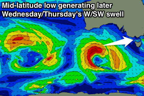 This should see a fetch of W/SW gales generated through our western swell window before the system weakens while approaching us and moves across Tassie. This should produce a medium sized W/SW groundswell to 3ft+ around Torquay, 3-4ft at 13th Beach and 6ft to nearly 8ft on the Mornington Peninsula late Wednesday and Thursday morning.
With the low dipping across Tassie on Wednesday we'll see onshore S/SW winds into the afternoon, but come Thursday a return to offshore NW winds will create great conditions on the Surf Coast. This will be the day to plan around next week for a surf west of Melbourne.
Beyond this there's nothing too major on the cards, and a possibly low forming off the Eastern Seaboard may bring with it a stormy SE windswell the week starting the 9th of June, but we'll review this Monday. Have a great weekend!